


The benefits of 3D laser scanning – being able to quickly capture a structure or site in detail – are applicable to many industries. The many applications for this technology mean that becoming a specialist in 3D laser scanning can help you to grow your business by reaching out to industries you may not have worked with before. TruePoint Laser Scanning is a fast-growing Ohio-licensed engineering firm that provides 3D laser scanning services to some of the biggest companies in the US. Here we look at a few examples of how they have used the same scanning solution – one of Leica Geosystems’ most versatile survey-grade solutions, the Leica ScanStation P-Series – in diverse projects for customers in construction, power and plant and heritage.
Leica ScanStation P-Series: Versatility with fast long-range scanning
The ScanStation P-Series 3D laser scanners are your perfect partner whether you are generating 3D data for integration into Building Information Modelling (BIM), capturing 3D geometry of civil infrastructure or creating an as-built representation of a large industrial complex. An accurate long-range scanning tool – up to 270 metres with the P30/P40 and up to 1km with the ScanStation P50 – you can capture data from further away when required. Capture data quickly at an extremely fast scan rate of 1 million points per second and feel confident to enter any environment, with hardware that performs even under the toughest environmental conditions.
Crucially, you can also check your work while you’re still on site: the Leica Cyclone FIELD 360 app now links 3D data acquisition in the field with the ScanStation P-Series laser scanners. Pre-register and examine captured scan and image data while you work to get the survey right in one visit.
Laser scanning in Construction: Promoting successful vendor coordination
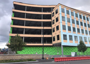 For a construction project in Ohio, TruePoint Laser Scanning was asked to capture the exterior façade of a newly built six-story building, measuring approximately 15,000 sq. ft. The team needed to work around various other tradespeople on the job site, so to cause the least disruption they laser scanned the building at a distance, in one day, using the ScanStation P50.
Using the 67 laser scans captured, TruePoint’s modelling team created a comprehensive set of architectural drawings that the client could use to fabricate all the necessary components. The client received clean, precise measurements of all areas needed in a digital format that could be easily shared with all vendors involved. Having consistent drawings that could be repeatedly referenced saved time and avoided wasting excess materials.
Power and plant: Laser scanning a natural gas facility with minimal disruption
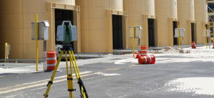 A sand frac client in Texas asked TruePoint to assist with plans to extend its facility. The client wanted to add new equipment and piping to the existing silos but did not have accurate 2D drawings or 3D models of the multi-acre site. To move forward, the client required an accurate 3D model and TruePoint was asked to accurately capture vessels, piping, mechanical equipment, and structural steel to create an LOD 300 AutoCAD model.
Since this was an active facility, TruePoint was able to laser scan the functioning silo lanes using a ScanStation P50 with minimal operational downtime and limited disruption of the site environment. TruePoint efficiently captured the data and quickly turned it into a useful, accurate representation.
Heritage and preservation: Creating as-builts of historic buildings quickly
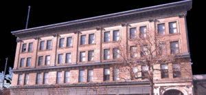 A construction client in Colorado was renovating an old, abandoned hotel into new apartments and asked TruePoint to create current and accurate as-built models of the building’s interior and exterior for preservation planning. TruePoint’s scan technician used a ScanStation P40 survey-grade 3D laser scanner to collect data points that are sub-centimetre accurate.
A process that could have taken months was reduced to a matter of days while yielding far more comprehensive and accurate data. The precise information captured by the scanner allowed TruePoint to model the historic detail that was important for the client to preserve.
Resources to help you get the most of your 3D laser scanning solution
For more information about how TruePoint uses 3D laser scanning to tackle extremely technical engineering challenges, read the guest post from Ryan Hacker, President, TruePoint Laser Scanning.
To help you get the most from your ScanStation P-Series, Leica Geosystems offers comprehensive training, including a wealth of free online resources to help you at every stage of the 3D laser scanning workflow: be it capture, management, collaboration, delivery or downstream use.
Visit our Pure Surveying website for content for every skill level across all sectors, from how to grow your business with laser scanning to how to improve your skills.