


Jesús Bonet Scanning Business Manager – Europe Terrestrial Laser Scanning I Reality Capture
We often talk about BIM – the process of Building Information Modelling – as part of the digital transformation of the building construction industry. But what is involved and why is it such a beneficial shift? As BIM becomes more widely used, methods for capturing and digitising a construction or restoration project, like Scan-to-BIM, are becoming more critical. Here we take a step back to look at some definitions of BIM; and then discuss the role of 3D laser scanning to gather data for a BIM model. We look at how it can be used at every stage throughout the building lifecycle – whether it’s capturing an empty site or an as-built environment – and how it benefits the project teams who use it.
What is BIM?
 In 2019 the first of a new set of International Standards were published to standardise the BIM approach globally (ISO 19650). These were based on standards developed by the UK body BSI, which describes BIM as “the management of information through the whole life cycle of a built asset, from initial design through to construction, maintaining and finally decommissioning, through the use of digital modelling.” The BSI definition stresses that the BIM process is collaborative, letting a team of people with different roles, e.g., engineers, owners, architects and contractors, better share information “in a three-dimensional virtual construction environment.” In its recommendations for managing information, the ISO explains Building Information Modelling as the “use of a shared digital representation of a built asset to facilitate design, construction and operation processes to form a reliable basis for decisions.”
What is the Scan-to-BIM process?
 Scan-to-BIM is the process of digitally capturing a construction site or existing building using 3D laser scanners, then using this information to create or update a Building Information Model. The first step – the Scan – is data capture. Operators use a 3D laser scanner to scan a site and create a point cloud, [All you need to know about Point Clouds] a set of data points or coordinates in three dimensions. 3D laser scanning, which uses Light Detection and Ranging (LiDAR) technology, can be an extremely fast process. For example, the Leica RTC360 3D laser scanner has a measuring rate of up to two million points per second. It can create a complete coloured 3D point cloud of its environment in under two minutes.
Next, the ‘to-BIM’ part. Once a site has been captured or mapped and a point cloud created, the information is processed and made into a 3D model that can be used in digital planning. Various software solutions are available to create 3D models, for example, the BIM authoring tool Autodesk Revit. Leica Geosystems customer Trimetari Consulting used Revit in a BIM-reconstruction of a 100-year-old historical building, located in Moscow’s centre. For Trimetari, the most important task for data processing is to get an actual as-built model of the building. To accelerate the process, they use the Leica CloudWorx for Revit plug-in to automate structures modelling and efficiently visualise and create BIM models from large point cloud data sets, creating 2D and 3D drawings.
When the BIM model is complete, extra non-geographical information can be added, making it the one central source of all project data – the ‘reliable basis for decisions. For example, in Trimetari’s reconstruction project, they used a stage tool in Revit to specify in the project the critical stages of the work and to link the erection and demolition of objects to them: “A complete BIM model of all types of works is, thus, formed in one file with exact documentation and specifications.”
When do you use Scan-to-BIM?
 As already mentioned, Building Information Modelling can and should be used throughout the building lifecycle. Scan-to-BIM can be used to inform the BIM Model at any stage too. The most obvious point is at the design stage. When there is an existing structure – as in Trimetari’s project – reality capture of as-built conditions can provide the model with the critical information that a designer needs for remodelling, reconstruction or renovation. When there isn’t an existing structure, laser scanning a site can tell the design team essential information about site considerations, such as landscape features and adjacent buildings’ position.
Scan-to-BIM can be used during the building and maintenance phase. For example, Sertogal SL used Leica Geosystems’ laser scanning solutions to create a BIM model that guided the remodelling of an electrical substation in Spain. A substation is a complex structure with many elements: wires, tubes, isolators and circuit breakers for example. A laser scan meant that the team could make an accurate model that captured all of these components and a BIM model that included linked information for each part. “This enables all parties to review how the projected developments will look and how changes will transform the current space…To manage operations in the future and drive workflows with accuracy and in a more productive way.”
Summary: the benefits of Scan-to-BIM

The benefits of BIM are huge. Jøns Sjøgren, Chair of the ISO BIM technical subcommittee said users had already been shown to save up to 22% in construction costs. Scan-to-BIM contributes to time and cost savings in the following ways:
- Increased speed: Dutch company BIM4ALL recently used laser scanning for a project to document sewer pits across the whole country before renovation. Traditional means of excavating the pits would have taken too long and been too costly, when “using laser scanning, however, a composite mold can be made to renovate the corrosive areas in less than a day.”
- Increased safety: Use 3D laser scanning to capture information at a distance, significantly reduces the risk to operators. In the sewer example, laser scanners were lowered into the pits rather than people. In the substation project, the laser scanner allowed the team to capture the position of live electrical elements without putting operators in dangerous high voltage areas.
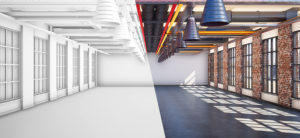
- Increased detail: 3D laser scanning gives you the ability to see a site in a reality-like level of detail and combine exterior and interior elements – all captured in one visit.
- Reduced rework: The high degree of accuracy provided by 3D laser scanning means that inaccuracies are avoided from the planning stage onwards, not designed into the project, creating problems later on.
- Reduced travel: Having a visual model, a digital twin, means that everyone involved in the construction project can understand and explore the site without making visits. Tools like Leica Cyclone 3DR Free Viewer let surveyors share access to key data visualisation and simple analysis tools with others on the team, making it easy to visualise point cloud data whatever your level of expertise.
- Increased collaboration: The collaborative BIM process means everyone works from the same detailed and accurate information source, making problems easier to identify and faster to resolve. For more information on our laser scanning technology, visit our website. For more information on BIM, download our article Improving Documentation & Quality Control in a BIM environment and our white paper Unlocking the Value of BIM.