


When we think of smart cities, we think of connected devices and spaces that are efficient, sustainable, and futuristic. And while this is important, this vision fails to recognise the people at the very heart of every smart city. After all, the driving force behind smart cities is to offer people a different way of living, with an emphasis on quality of life.
Another missing element is the opportunities smart cities present. Yes, they’re designed to overcome the genuine problems we face in cities today, but smart cities are constantly evolving and adapting to the ever-changing needs of society.
In this blog, we’ll share the techniques used to create smart cities in Asia and Europe. We’ll also explore the technologies driving smart cities to be even smarter, the opportunities for planners, and the user-friendly yet advanced technology of the future.
Smart Planning in Action
 Singapore: Building smart cities from the ground up
Often recognised for its technological ingenuity and sustainability, Singapore is a country that embraces technology to improve the lives of those who live and work there while also bridging the digital divide. The smart planning techniques used in Singapore are part of a larger strategic framework for sustainable living.
For urban planners in Singapore, the first step when creating a new smart city is to capture the environment through a visual 3D model. Smart Digital Reality with reality capture and digital twin technology enables planners to see the available space.
Planners in Singapore are leveraging 3D models to analyse energy efficiency. For instance, wind flow analysis optimises the positioning of buildings, so natural wind flows cool down city centres. Similarly, solar panel analysis enables the optimised capture of natural energy. Both examples increase a city’s sustainability.
But that’s not all. Creating a realistic 3D model aids planners to determine the optimal locations for outdoor spaces, shops, and restaurants. Planners can better implement transport routes and proactive maintenance strategies through real road usage analysis. This has two benefits; it ensures road conditions are maintained and that work is undertaken at a convenient time.
 Barcelona: The Evolution of a Smart City
As a historic city, the urban planners for Barcelona cannot build smart cities from the ground up. But this hasn’t stopped Barcelona from becoming one of the leading smart cities in Europe. The biggest challenge in achieving this accolade has been finding solutions that update the existing infrastructure without compromising on the city’s unique features.
This has been a success as Barcelona is recognised globally for its readiness to adopt new and emerging technologies that further its strategic vision to embrace data-driven connectivity, sustainability, and mobility so its residents can live an enriched and connected life. So how did urban planners achieve this?
It all began with sensors, thousands of sensors including cameras, which were used to monitor everything from waste bins to air quality, pollution, noise levels, traffic flows, and more to create a real-time overview of the city. The information is automatically uploaded to a server where it is processed and analysed so practical solutions can be implemented.
For instance, if a road is frequently congested, causing high CO2 levels, the entire block could be closed to improve air quality and give residents a better quality of life. This highlights how planners can implement data-driven solutions that positively impact society. As data is continually being collected and analysed, solutions can be monitored and adjusted as necessary. In this way, technology is empowering individuals and organisations to make better, informed decisions.
Optimising urban planning in Singapore and Barcelona has ensured the best environment for those living and working there. Creating infrastructure enables planners to overcome many of the challenges we face today. But making plans efficient is even better because it means the smart cities of tomorrow are ready to face the challenges we cannot yet imagine.
Mapping the Future: Mobile Mapping Technology
As the case studies show, smart cities need agile advanced solutions to optimise urban planning for efficiency. And the only way to achieve efficiency is by collecting and analysing real-time data. Access to real-time data has a transformative effect on projects, which is how smart cities should be viewed.
It’s no coincidence that the critical components of a project are the same as those required for smart cities (planning and design, construction, operations and maintenance). Data collection is one of the biggest challenges facing cities that want to become smart. How can such a large volume of reliable real-time data be collected? This is where Hexagon comes in.
And as smart cities are constantly evolving, so is the Hexagon technology powering them. The latest Leica Pegasus TRK mobile mapping range has developed to meet the changing demands of planners, digital natives, and industry. Next-level technology today focuses on autonomy, intelligence, and simplicity to bridge the divide between users and advanced mobile reality capture technologies.
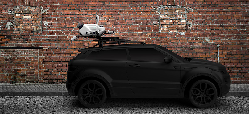
Hexagon understands the challenges users have faced in the past, which is why the Pegasus TRK range is user-friendly for new adopters, experts, and everyone in between. While the Pegasus range has always allowed for real-time data collection in applications such as disaster planning, Building Information Modelling (BIM), asset management, and surveying (both indoor and outdoor), the Pegasus TRK range enables users to create specific instructions for data collection in a specified area.
It triggers sensors for autonomous data collection and as it is solution-focused, users can access real-time data anytime, from anywhere in the world, through streamlined workflows. It’s also flexible, offering a system with a single scanner (Leica Pegasus TRK500 Neo) or a dual scanner (Leica Pegasus TRK700 Neo), which collects 1,000,000 measurements per second. In addition, the range offers built-in privacy features, as smart cities are nothing without the people that live in them.
Smart is Good, but Smarter is Better
Smart cities are the cities of the future. They offer sustainability, economic opportunities, and a better quality of life for residents. But not every city can easily be transformed. Smart cities must be viewed like projects and developed with efficiency and optimisation in mind.
Hexagon is helping to transform cities worldwide with its mobile mapping technology. It understands data capture and processing challenges, which is why it focuses on innovative solutions and the user experience. This has enabled Hexagon to create advanced yet user-friendly technology for novices and digital natives. After all, smart is good, but smarter is better.
 Alessandro Nuzzo
Product Manager Mobile Mapping Systems
Reality Capture Division
Visit our website to learn more about Leica Geosystems’ Mobile Mapping Systems.