


Whether you prefer photogrammetry, the geolocation approach or 3D laser scanning in your crash or collision documentation, Leica Geosystems offers you fit-for-purpose solutions to create a “Forensic Digital Twin” (a full and complete, holistic capture of the scene, preserved in a digital format) of the scene you work at. Because working in a live traffic environment can be inherently dangerous, we have optimised all our solutions to make your job of collecting evidence safer, and as intuitive and efficient as possible without sacrificing flexibility, accuracy, and comprehensiveness.
Our geospatial technology serves users from different backgrounds and caters to the full range of needs and budgets. The different types of solutions are shown below in order of increasing sophistication.
COMPACT HANDHELD PHOTOGRAMMETRY WITH THE BLK3D
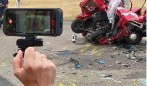
The BLK3D imaging laser scanner is a flexible and easy to use all-in-one photogrammetry handheld solution. With a calibrated stereo camera, measurement sensors, software, and on-device edge detection capabilities, every image captured is a complete and precise 3D measurement record. Designed to make taking measurements faster and easier, it is the perfect starting system for investigators who want in-picture measurements with professional-grade accuracy.
Back in the office, the photos and measurements captured by the BLK3D can be exported to Leica BLK3D Desktop Software or other industry-standard software to extract various measurements or to create 2D scaled drawings of the scene showing objects, landmarks, evidence, vehicles, etc.
READ THE ARTICLE: Crash, Crime Scene Rectification with the Leica BLK3D
MANUAL AND ROBOTIC TOTAL STATIONS
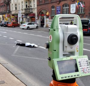
On scenes that are too large for accurate photogrammetry, our manual or automated Total Stations are a productive alternative for capturing distance and position measurements with great accuracy. Manual total stations are used with the Leica Captivate software. This way the investigator can participate in the world of 3D by benefiting from 3D views of the measured data. The TS10 manual total station offers also the AutoHeight feature as an option. AutoHeight enables the instrument to automatically measure, read and set its instrument height. This feature helps eliminate critical errors during the instrument setup by using a laser to measure to the ground and automatically passing the measurement to the software. Leica Geosystems manual total stations focus on providing the highest quality, the lowest total cost of ownership and the longest durability in the industry.
With the recently introduced smart system Leica AP20 AutoPole, used with our robotic total stations, investigators can significantly save time at the crash scene. This solution allows measurements with a tilted pole, provides automatic height readings, and enables target search and “locking”. The user can adjust the height and tilt the pole to reach a hidden point, quickly re-establish line-of-sight and relock to the robotic total station. Using robotic total stations with the AP20 AutoPole, you can continue and complete your crash scene documentation with high reliability and minimise rework and delays.
READ THE CASE STUDY: Forensic Mapping: Polish Police uses Leica Geosystems Total Stations for Crash Documentation
PRECISION GEOLOCATION FOR POINT-TO-POINT MEASUREMENTS WITH GNSS
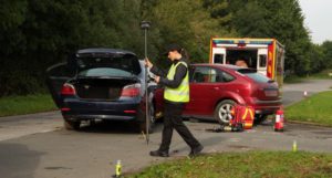
The GS18 family of GNSS smart antennas provide a versatile and accurate satellite-based positioning system. Basic GNSS geolocation systems have some form of antenna known as a rover on the end of a pole that you position upright at the point you want to measure. In the GS18 T, a real-time kinetic (RTK) compensation system is added so that the rover and pole can be tilted without affecting measurement accuracy.
Finally, in the GS18 I, a powerful automated imaging system was added. This means that while you can make point-to-point measurements in the usual manner, you can also walk around capturing the scene at 2 frames per second. This means that you never leave the scene with the nagging doubt that you might have forgotten an important measurement. Back in the office, the measurement data and images can be seamlessly sent to Leica Captivate software for analysis and the images allow you to extract any additional point positions with ease.
WATCH THE VIDEO: GS18 I: A Remarkable Innovation in GNSS Collision Investigation
COMPREHENSIVE AND IMMERSIVE 3D DOCUMENTATION WITH THE RTC360
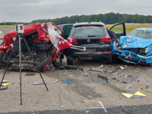
3D laser scanning has revolutionised the documentation of crash scenes. But faster and more efficient and comprehensive data collection is only the beginning: Using Leica’s Reality Capture solutions, you can create a Forensic Digital Twin of the scene. This allows you to capture your data quickly, and then work on your hypothesis in a safe virtual environment.
The RTC360 high-performance 3D laser scanner combined with Leica Cyclone FIELD360 and office software is the ultimate solution for an effortless and seamless workflow. With this toolkit, you can capture a 3D virtual representation of the crash scene in real-time that users can later explore. This kind of documentation is known as a Forensic Digital Twin, and it allows for more immersive investigations and more decisive court processes.
The RTC360 laser scanner allows you to capture high-quality 3D scans at a rate of up to 2 million points per second and enrich them with High-Dynamic Range (HDR) imagery. An entire point cloud can thus be registered in less than 2 minutes. Furthermore, the system can automatically register the scanner’s move to the next position using the in-built Visual Inertial System (VIS) and thus pre-register scans in the field.
In the past, the investigator and the emergency response crew could get in each other’s way. Now thanks to the speed and agility of the RTC360 you can work faster. And a double scan feature automatically removes moving people from point clouds, ensuring that you never waste a minute waiting for someone to stand clear.
After adding additional tags and comments in the field, you can directly publish data from Cyclone FIELD 360 to the Leica TruView Cloud to share it with other team members or proceed seamlessly to Cyclone REGISTER 360 to create the immersive Forensic Digital Twin.
By the way, forensic mapping software such as Leica Map360 can integrate collected scan data directly with for example CCTV footage, images, and other relevant documents into models for analysis and hypothesis.
READ THE EXPERT INSIGHT ARTICLE: Inside the Mind of a Crash Scene Investigator
Our solutions:
– IMMERSIVE –
The Forensic Digital Twin created on a crash scene allows investigating parties to do as many virtual site walk-throughs as they want, looking at the scene and evidence from different angles.
– DECISIVE –
Our crash and collision investigation tools provide a solid basis for data-anchored decisions.
– PROTECTIVE –
Our technology allows you to collect evidence more quickly in hazardous environments without sacrificing accuracy and future investigative options.
For more information please contact our Public Safety experts or visit our Public Safety, Security and Forensics website.
Do you want to stay up to date? Follow our Public Safety, Security and Forensics channel on ![]()