


The Leica Cyclone FIELD 360 mobile device app is the perfect field companion for the Leica RTC360 3D laser scanner and the Leica BLK360 imaging laser scanner, so you can work seamlessly, anywhere.
Cyclone FIELD 360 links the 3D data captured in the field with post-processing activity in the office, offering added functionality that makes documentation of the built environment more efficient, accurate and flexible. Currently available on tablet computers, the app will soon be available on all smartphone devices, making the power of reality capture more portable and flexible for users.
Discover 5 key benefits of using the Cyclone FIELD 360 app on your mobile device, from improved quality control to more efficient workflows:
1. Boost productivity
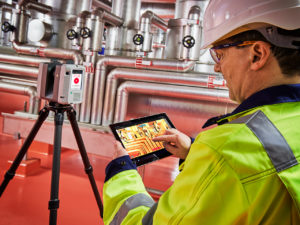
The Cyclone FIELD 360’s compactness, flexibility and remote-control capability are combined to improve the user’s productivity. The powerful app is the perfect onsite companion to visualise captured scan data in the field. Users can choose which device (e.g. tablet computer or smartphone) to use in the field, so they can work in the way that suits their data capturing process/fieldwork preferences.
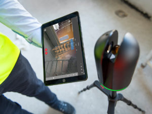
App visualisation features, such as Intensity Colouring, Tagging, Silhouette View and Scanner Live Position (RTC360 only), all offer enhanced functionality at the push of a button to support and streamline on-site processes. Such features contribute to minimising manual work and freeing up time for teams to focus on other tasks.
2. Easier pre-registration
Scan data from multiple setups captured with the RTC360 laser scanner are automatically tracked and processed by the unique Visual Inertial System (VIS) technology. The captured scan data is transferred immediately in real time and setups are pre-aligned for instant visualisation within the Cyclone FIELD 360 app.
User operation is simple and intuitive: the app automatically presents a bird’s-eye view of the scans in 2D mode, allowing you to carry out a quick visual alignment by simply dragging and rotating them. At the click of a button, the Quick Link auto-alignment feature ‘tightens up’ the visual alignment so that links can be created between multiple scans, locking them together as a bundle. When transferring the data to Leica Cyclone REGISTER 360 post-processing office software on your desktop, you will find the entire point cloud is pre-aligned, just like it was on your smartphone or tablet computer. Use Cyclone REGITSER 360’s robust QA and cleaning tools to finalise and publish your registered project downstream.
Users capturing multiple setups with the BLK360 imaging laser scanner, can now benefit from the new Pre-Align feature within Cyclone FIELD 360. Unlike the RTC360, the BLK360 Pre-Alignment does not rely upon VIS technology. BLK360 Pre-Alignment detects the geometry of the scans, such as walls and major scene features, and at the click of a button, approximates their orientation so you can start to create a bundle.
3. Data tagging on-site

Adding tags anywhere on your captured scan data, streamlines workflows from start to finish. Your field team can conveniently annotate tags with measurements, videos, images, voice files and simple text, improving the context of the captured data and 3D models and eliminating potential data siloes between site and office.
On-site tagging is fast and simple – tags persist within Cyclone REGISTER 360 and downstream into TruView, JetStream and CloudWorx for seamless integration from field to finished.
4. Quality control in the field and office
Direct data access is essential for quality control in the field, so full imagery and point cloud data are delivered directly to your smartphone or tablet computer. With Cyclone FIELD 360, the pre-aligned point cloud data can be visualised in 2D, 3D points and 360 imagery, so users can quickly conduct on-site quality-control checks and make better informed decisions about quality and completeness in the field.
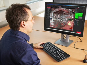
Cyclone REGISTER 360 post-processing office software makes it easy to understand the quality of your data through intuitive colour-coded error reporting which users can customise per project needs. When you have completed a project, confidently publish a Registration Report, including detailed quality reporting and image assets to deliver to your clients.
5. The entire project in 3D on your mobile device
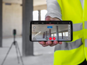
With Cyclone FIELD 360, users can instantly view captured point cloud data in 3D on their smartphone or tablet computer. This app is provided exclusively by Leica Geosystems for iOS and Android. It is a truly unique solution in the laser scanning technology market.
View single scans or an entire project depending on user preference: in full High-Dynamic Range (HDR) colour, rainbow intensity or grey-scale mapping on your mobile device, and navigate it in 2D, 360° panoramic view, or in full 3D.
Find out more about how the Leica Cyclone FIELD 360 mobile device app.