


Software is at the centre of users experience, allowing us to access, share, create and interact with digital data in intuitive and productive ways and unlock various applications. Whether you are looking for one easy-to-use field software across your GNSS and TPS equipment or you already standardised on Leica Captivate Field Software, this blog will guide you on what to look for when selecting a surveying field software.
1. Look for a surveying field software that helps you improve those things you do everyday
Does your field software simplify your workflows with targeted apps? Does it help you choose (and use) the right data and tools?
Surveyors often need to repeat routine tasks, sometimes multiple times a day, like setting up a total station, toggling codes during data collection, or switching between prism and non-prism mode. Beyond simplifying the setup with hardware and accessories, field software can significantly simplify daily tasks, such as feature coding, linework, and staking points and lines. Keeping these fundamental elements easy is very important for an enjoyable user experience.
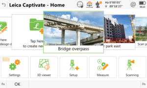
Captivate was designed by surveyors and engineers. These professionals understand the tasks and challenges surveyors are facing every day out in the field. Be it a topographic survey, the staking of roads, railways or tunnels, monitoring, scanning, GNSS campaigns, or virtually any other measurement challenge: you can be sure Captivate has an application designed to solve any measurement task. Captivate provides streamlined workflows to help users complete everyday tasks (such as staking or checking a reference line, a road, rail, or tunnel design, or computing a stockpile’s volume – to name a few) or more detailed tasks (like Auto Setup, Auto Stake, inventory management, and pipeline surveys – again, to name just a few.)
2. Look for an easy-to-use, intuitive and interactive surveying field software
How long will it take to get familiar with the field software? Does it provide automated routines? Is data clearly and graphically displayed?
“Intuitive” means something looks familiar, discoverable, clean, clear, and consistent while “interactive” suggests you can experience and act on it. A surveying field software should be as intuitive as possible, but also it should be powerful and effective. It should go beyond data collection, by helping you to interact, enquire and straightforwardly learn from your data.
From basic skill level to experts who need to perform highly-technical tasks, Captivate provides an intuitive and unique user experience. It is simple to use, comes with familiar touch technology and easy-to-use apps, plus its easy coding enables “CAD-ready” data to be quickly created.
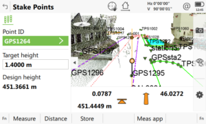
Beyond a clean and attractive appearance with customisable and interactive displays, Captivate provides a clear graphical 3D display of the collected data, intuitive coding, advanced automated routines, and extensive COGO computations, delivering a captivating experience.
3. Look for a surveying software that allows you to make decisions directly in the field by interacting and viewing data in 3D
Is your surveying field software allowing you to make faster decisions while still in the field by using rich 3D data, such as point clouds? Do you need to return to the office to upload data in post-processing software?
Surveyors make 3D measurements and consume and create 3D models; however, for years, only 2D coordinates were displayed graphically in survey field software. We all live in a 3D world – we interact with CAD files, DXFs, IFCs, and even ASCII files that contain 3D data. Therefore, we must be able to view and interact in 3D too!
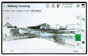
Captivate allows 3D data to be seen and interacted with in 3D – not just in one place but throughout the software. With the ability to merge the overlay of measured points, 3D models and point clouds into a single view, Captivate users can manipulate onscreen displays to exactly create and check any work on site. With Captivate, surveyors can make decisions directly in the field performing detailed data analysis, such as using a point cloud for flatness analysis or as-built checks.
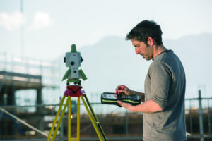
4. Look for a software that allows you to save time as you switch between projects and equipment
Can the software be used across all your TPS and GNSS portfolio? Do you need to learn different software for every instrument? Can you trust the data you instrument collects?
Surveyors may have several survey or construction projects and possibly be moving between them daily. This means not only taking your instrument to a new location but also switching the measure job, setup data, design data, coordinate system, etc. Using one standard field software between surveying instruments enables a cohesive work environment, saves time when switching projects and training time is reduced as surveyors use the same software across all surveying equipment.
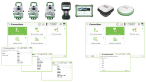
There is a broad portfolio of instruments supported by Leica Captivate. The field software is equipped in field controllers and tablets, the Leica CS20 field controller and Leica CS35 field tablet. Captivate can be used directly on several total stations, including the new generation of total stations and MultiStation, legacy ones, and some non-Leica Geosystems manual ones. As well as our latest GNSS receivers, including the GS18T, GS18 I, GS16 and the GS07.
When using Captivate in any of the instruments mentioned above, switching jobs is done by a simple swipe in the home panel. Captivate users can select the job or project, activating the linked design, control and alignment data automatically in the background. Users have the option to show or hide points and lines in the dataset. Users can also select several jobs containing control and design data and link them all to the same working job.
5. Pick a field software solution that is backed up by trusted services and global support
Does your solution come with professional support and service in your region? Does your software offer cloud connectivity with data transfer and file sharing? Can you access training and learning material?
An enjoyable experience when using measurement technology goes beyond software and hardware and includes knowing that you can count on reliable support. Support comes in many forms, whether as a service that helps you to be more productive, an experienced technician to help you solve problems, keeping you productive, or a training or learning centre to get the most out of the solution.
The Leica Captivate Experience goes beyond the core elements of engaging software and precise hardware but includes trusted services and support. With a global support network and more than 250 service centres worldwide, you can be sure an experienced technician will be ready to troubleshoot any issues. Captivate services will also help you to embrace cloud data with Leica Exchange, web map services, web feature services, and more. With a smooth data transfer, you can process faster the information back in the office with Leica Infinity and export into third-party software.
All this is rounded by online resources and learning tools to maximise the use of your solution.
In your quest for surveying field office software, you should evaluate the overall experience and look at all the components of a solution, including hardware, software and services. To get the most out of the best hardware, it makes sense to use the software that was specifically designed to empower it. The instruments the software powers must be able to take on any measurement task under any conditions, assuring you that data collected is accurate and reliable.
Read how businesses are taking full advantage of Leica Captivate or watch the webinar “8 key features of Leica Captivate software that boost efficiency of your survey tasks.”
Discover the benefits of Leica Captivate.