


The collapse of an eight-storey building in Istanbul’s Kartal neighbourhood on a Wednesday afternoon in February 2019 shocked the nation. It happened almost 20 years after a powerful earthquake shook the densely populated Marmara region to the south of Istanbul, Turkey’s largest city, for 45 seconds. Many thousands lost their lives. Sitting between two huge tectonic plates, Turkey is extremely vulnerable to earthquakes because of its geographical location.
When a natural disaster hits, immediate action is required to prevent loss of life and analyse what happened. That is why in Turkey, a mobile laboratory (MOLAB) was built.
What is MOLAB and Why it is Vital for Disaster Recovery?
Mobile LABoratory (MOLAB) was built straight after the Kartal disaster, and Murat Kurum – the Minister of Turkish Environment and Urban Planning – was the mastermind for this vehicle.
When there is an emergency, specialised teams are mobilised immediately to the scene with all the required equipment and instruments inside the MOLAB. Teams can check damage to all features, such as the ground, buildings or bridges.
Equipment in the MOLAB can also quickly assess, for example, corrosion to iron structures, on location at the disaster site without needing to go to another laboratory. This is a great advantage to specialists who operate MOLAB, as they can quickly determine the collapse risk for still-standing buildings and structures.
Rapid Reality Capture of Disaster Locations and Scenes is Key for Response Teams
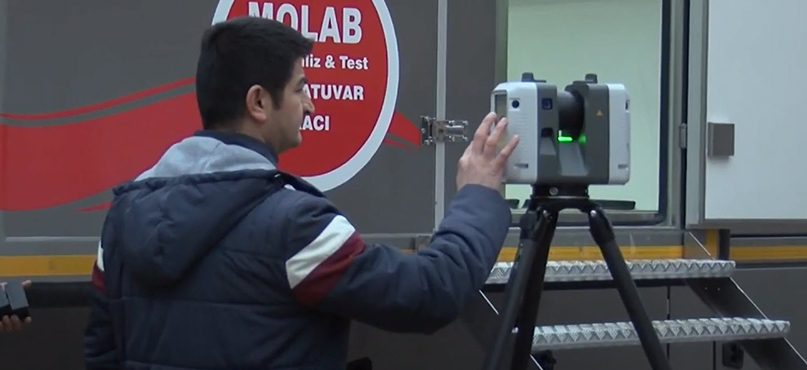
The ability to set up and quickly capture the scene of an incident in minutes is critical to the preparation of response strategies, preserving life and preventing further damage. The Leica RTC360 3D laser scanner is one of the vital instruments within MOLAB, allowing response teams to capture points and position data of all buildings with its scanning range of up to 130 m. The RTC360 creates a digital visualisation of the scene in a few minutes and provides 3D documentation, which can help prevent further damage or injury.
The laser scanner measures up to 2 million points per second and saves this data in its on-board memory and combined with Leica Cyclone FIELD 360, a lightweight preview object is available for instant visualisation at the scene. At this stage, the specialists in the disaster recovery team take various measurements at the location. Once data is transferred to a computer for post-processing inside the mobile laboratory, measurements are repeated at to overlap the data captured from various angles.
By assessing the measurements directly on-site, teams can identify which buildings are at risk of falling before they collapse and can ensure people are moved away from the buildings and surrounding areas.
Final Calculations for Damage Assessment
One of the most critical tasks of disaster prevention is damage assessment. Specialists working in Turkey’s MOLAB are able to transfer the data captured by RTC360 and collaborate with the data obtained by their teams from other sites and scenes to make critical decisions as to the viability of structures in the future.
With reality capture and the use of 3D laser scanners, the status of buildings can be checked onsite in a much quicker fashion. In January 2020, just after the 6.8 magnitude earthquake in Elazig, in Eastern Turkey, the RTC360 was used to assess the damage. Before the buildings were demolished, teams on-site were able to capture highly accurate and detailed 3D data. In planning for the future, and with a view to preventing tragic loss of life, disaster assessments help inform the authorities when introducing tighter building codes, revising urban planning and improving key public infrastructure.
For more information about our laser scanning solutions, please contact us.