


Governments worldwide are currently spending more money on infrastructures such as roads, bridges and tunnels. According to a report by PWC, worldwide infrastructure spending will grow to more than $9 trillion annually by 2025. This will help boost global economies coming out of the pandemic and update infrastructure to the latest standards in safety and sustainability, as well as reduce waste of construction resources such as concrete.
In this blog, we look at the principal ways surveying professionals use reality capture technology to improve workflows in highway and road projects throughout the design, construction and maintenance phases. It also examines how new surveying technologies are driving digitalisation in the construction industry, by connecting people, data and machines.
Data capture for the design of highways and roads
 Traditionally, the initial work of a surveyor when creating new highway and road infrastructure was work-intensive and time-consuming. Projects tend to require multiple site visits to ensure designs are precise, and there can be delays caused by staff absences or adverse weather.
Changing project requirements based on older analogue designs and inaccurate measurements requires rework. This wastes resources and ends in difficult stakeholder management. At worst, if mistakes are made from not having the right data to start with, the situation could result in large, costly over-runs.
Using today’s surveying equipment from the start to create and design highway and road infrastructures removes these pain points and increase efficiencies and safety. This includes improving safety as reality capture technology makes workflows more efficient by reducing the number of surveyors on site, in this case, on dangerous and busy routes.
Point clouds generated from 3D laser scanners or mobile mapping systems, for example, can be processed in Leica Cyclone office software to create a model that can be used in the design phase. When the model is complete, it can be shared with various project stakeholders on-site via Leica ConX, a cloud-based collaboration tool that allows you to efficiently manage your connected construction projects and share job-related data to validate models. Alternatively, surveyors can invest in a Leica Exchange service to easily transfer unlimited amounts of data between the field and the office.
It is important to remember that a well-designed project increases the chances of completion on time and on budget.
 For the critical capture and design stage, mobile mapping systems such as the new Leica Pegasus TRK record, measure and visualise large environments, increasing productivity. The Pegasus TRK, for example, is light enough to be operated by one person, resulting in more cost-effective mapping projects from the outset. It is also user-friendly, so suitable for surveying professionals who may be new to the technology, but also serves the needs of technical experts. Integration of Inertial Measurement Unit (IMU) sensors and SLAM (Simultaneous Localization and Mapping) enables georeferencing where there is no GNSS, such as in tunnels or dense urban environments and aid mission navigation to ensure accurate point clouds. Another option for measuring points when there is an obstructed view to the sky, surveyors can employ the Leica GS18 I, a versatile GNSS RTK rover with visual positioning. The GS18 I captures the site in images and measures points for them: it ‘measures what you see’ to reach places you couldn’t before without needing to switch tools or climb through obstacles to increase safety on site.
This type of survey prepares for the maintenance and repair or upgrade of existing highways and roads, so creating a digital twin of the initial environment makes site planning and design more accessible to multiple stakeholders. Mobile mapping technologies such as the Pegasus TRK enable surveyors to quickly obtain detailed topographical surveys of highway features over large areas by capturing millions of points at high accuracy levels. These include the carriageways and verges, road markings, crash barriers, kerbs, signage, fences, overhead lines and even cracks in materials. Rapid data capture reduces the time surveyors need to be in the field and the need for multiple personnel to stand on the carriageway and verges day and night. This improves employee safety and contributes toward project delivery on time and on budget.
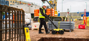 Underground utility mapping also helps avoid ‘utility strikes’ by mapping where underground piping may be located and enabling surveyors to designate no digging or excavation in those exclusion zones. Using Ground Penetrating Radar (GPR) technology such as the DSX utility detection solution or the Stream Up paired with a Pegasus mobile mapping system, surveyors can quickly locate and model utilities above and below ground at high speeds, reducing traffic flow impact and time on dangerous roads. The data captured is visualised via intuitive software that enables users to interface with various positioning systems and performs utility verification in 3D on-site.
Keeping the construction of highways and roads on track
Working on today’s construction projects demands efficiency and quick decision-making to stay on track and minimise rework. The Leica iCON site software enables non-surveyors such as field crews to create as-built checks of a site during construction. Less physical crew is needed on-site, reducing safety risks, and staff can conduct layout, as-built and verification tasks for site preparation and structures. With construction TPS and GNSS, speed is increased and performance and accuracy are improved, reducing errors, waste reduction and resulting in better construction execution.
Another method to monitor project construction is by UAV which enables millions of data points gathered from above to be processed and analysed, then visualised to provide actionable information. The data can also be combined with TPS, GPS and laser scanning for complete, detailed, accurate information. By taking only minutes to survey large and lengthy highways and roads, UAVs enable the swift completion of infrastructure builds at a lower cost and with fewer staff.
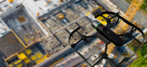 UAVs such as the Leica BLK2FLY can be strategically advantageous for the survey team when checking construction verticality, volume calculation and as-built checks versus design. In addition, safety is improved because the operator doesn’t need to enter the active site and keeps away from possible danger. Additionally, site activities can continue without interruption keeping the project productive while having up-to-date as-built data.
The ongoing operation and maintenance of highways and roads
Once the mainstay of the heavy work is completed, highways and roads for obvious safety reasons, need regular checking and maintenance. Reality capture technology can be deployed to do this, quickly and more efficiently, increasing surveyor safety on dangerous and busy routes; while capturing any deterioration such as cracks and uneven road surfaces.
The Pegasus TRK utilises enhanced-machine learning to record, measure and visualise environments. It is suitable for all critical infrastructure projects and its applications include as-built surveying, subsurface and asset mapping, inspection, restorations and decommission.
 The Leica Pegasus FIELD for fully autonomous and secure data collection and route planning in the field can help to continue the smooth operation and ongoing maintenance of a highway. As in the data capture stage, it connects with the Leica Cyclone Pegasus OFFICE for post-processing and publishing, i.e. the creation of an accurate and high-density digital twin of the site. This is then used to identify any wear and tear, and for example, to analyse the quality and reflectiveness of highway signage.
Reality capture: Unlocking the potential for future engineering surveyors
The potential of using reality capture technology in highway and road construction and maintenance for time-saving and simplifying workflow is vast, by their size and work intensity. These projects require surveyors to frequently check work against designs because it is vital the infrastructure is built correctly. If not, the consequences of rework and waste materials can be costly and have a high impact on the environment.
Digitalising infrastructures with reality capture technology provides multiple benefits and one example is the increased measurement density resulting in the completeness of the road’s surface. With roads, it’s essential to have a smooth surface. If the road doesn’t have the smoothness specified in the design, there will be more wear and tear, leading to more maintenance for highway agencies and motorists. By creating a digital twin that can be compared to the original design, surveyors can easily document differences like the unevenness of the surface. This also increases sustainability by removing unnecessary waste and reducing the use of extra materials.
Finally, adopting the latest reality capture technology is an excellent way to attract and retain new talent in the industry – the engineering surveyors themselves. The democratisation of geospatial data and the rapid advancement of reality capture technologies means next-generation engineering surveyors will be upskilled in their use in the future design, construction and maintenance of large highway projects.

Craig Hill
VP Marketing & Services Survey Solutions
Leica Geosystems
For more information, please visit our Pure Surveying website.
Learn more about key priorities for today’s surveyors.