


The design and build of plant extensions can be extremely difficult and time-consuming without the right preparation. Complete understanding of the environment with its complex structures is vital, along with total accuracy in the measurement of spaces and the design of a plant. Any mistakes or delays could have costly consequences.
There are many challenges to extending a plant: the inhospitable environment affects accuracy, especially if hand measurements are undertaken. Speed is crucial so workers spend minimum time on-site, though this impacts precision. Furthermore, plant navigation needs to be planned for maintenance contractors visiting the facility, with danger zones, safe areas and escape routes mapped out.
The Leica RTC360 3D laser scanner empowers users to measure, document and capture their environments in 3D, enabling designers to visualise the new and existing area in situ and to discover site possibilities with accurate graphical representations. They can also augment the data capture to illustrate the opportunities for better, more efficient planning.
Step 1: Capture the complex geometry of the plant
Firstly, you may not have as-built documentation to plan a plant extension, leading to many necessary site visits to gather the data accurately and comprehensively way. 3D reality capture enables you to replicate the physical world and turn it into a digital environment, which is particularly useful for complex plant environments where the geometry cannot be captured with traditional measuring tools.
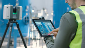
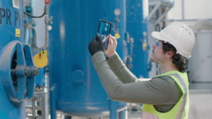
The RTC360 is the perfect laser scanning solution to measure and capture entire plant environments in 3D, producing accurate coloured point clouds that can be checked in the field with Leica Cyclone FIELD 360 mobile-device app, installed on your smartphone or tablet computer.
The resulting 3D model of the site – which is highly accurate, detailed and actionable – supports architects, structural engineers and developers on the planning of plant extensions, documentation and maintenance, enhancing collaborative workflows and improving operations.
3D reality capture empowers you and your team to design with confidence. Furthermore, the Cyclone family of products enables you to generate a wide variety of deliverables for your plant projects, from reports and maps to animations and lightweight 3D data formats that can be distributed online.
The RTC360 is built to be a fast, agile and precise solution:
- It measures at a rate of 2 million points per second, with full-dome scans and High-Dynamic Range (HDR) imagery completed in under 2 minutes
- Low noise data allows for better images, resulting in crisp, high-quality scans that are rich in detail
- Weighing less than 6 kg, this is a portable laser scanner that comes with a collapsible tripod and fits into a backpack
Step 2: Understand your environment completely
When a site is scanned as-built with the RTC360 solution, you can plan more efficient plant layouts with verified measurements and view hidden infrastructure and systems, as well as take existing assets into account for the extension. This gives you a complete understanding of your plant environment.
Furthermore, the ability to annotate the captured scan data on-site using Cyclone FIELD 360 is valuable for future extensions, particularly in clash prevention and ensuring new elements can be integrated within congested structures. Measurements, videos, images, voice files and text can be added to the captured data for improved interpretation and value.
Speed is of the essence when planning plant extensions so sites can be upgraded as quickly as possible to remain current and competitive. This would also minimise costs during the design phase, along with shutdown periods, if applicable. As-built scans captured by the RTC360 laser scanner allow teams to design and manufacture extensions quicker; they also enable designers to create additions without needing to access the site, using measurements that are accurate to the millimetre.
Importantly, safety will be increased as the number of site (re)visits to inhospitable plant environments are kept to a minimum – or completely eliminated. Faster, smarter, safer working for your field crew.
Step 3: Take action
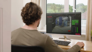
Now you have completely understood the environment and captured it in 3D, you are ready to head back to the office to check the scan data. As part of the integrated RTC360 Field-to-Finished solution, Leica Cyclone REGISTER 360 allows users of any level to work with the data, visualise it in great detail and collaborate more effectively.
This point cloud registration software will empower you to deliver professional-level project deliverables with ease. For new users, Cyclone REGISTER 360 provides guided registration workflows; for more experienced users, they will find their work is streamlined too.
REGISTER 360 will automatically place project data on real-world coordinates and complete a registration with little-to-no manual assistance from the user. Simple, yet powerful.
Find out more about how the Leica RTC360 3D reality capture solution can help you plan plant extensions better:
RTC360 podcast with Juergen Mayer
Discovering the power of scanning Q&A