


The need for maps in support of physical planning has increased undoubtedly in both developing and emerging parts of the world. World population is increasing, people are moving from rural to urban centres, and we need the right tools to control urban development and pollution, ensure sustainable use of natural resources, and protect the environment. Physical planning processes require geographical information (maps); over the past years, mapping methodologies and processes in the developed countries have improved, delivering a fast and accurate nationwide overview.
Hexagon is today mapping the United States of America (USA) and Europe on a regular basis in direct competition with satellite mapping programs with significant success.
Benefits of the new technology
Hexagon has over the last years built up a system for full and regular coverage with maps of the USA and Europe with the HxGN Content Program where the same data can be used by several partners (see more details under figures below).
Hexagon’s setup for content mapping is based on aircraft flying with cameras that are similar to satellite-based systems. The systems fly in 3 to 5 kilometres altitude instead of more than 400 km altitude as the minimum altitude for satellites.
The benefits are numerous, faster data acquisition with higher accuracy with less cost. Accuracy here means that data can be used for projects such as flooding, cadaster and more where satellite-based system are not accurate enough. Developed for urban or rural areas, the new technology supports the need for fast basic mapping and is now ready for use in any area of the world.
Besides the effective data collection, the data processing is based on software with a significant degree of automatisation, which not only makes the mapping cheaper but also faster from data collection to release for the market.
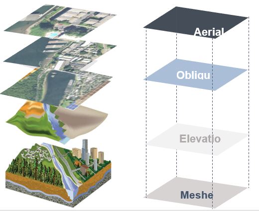
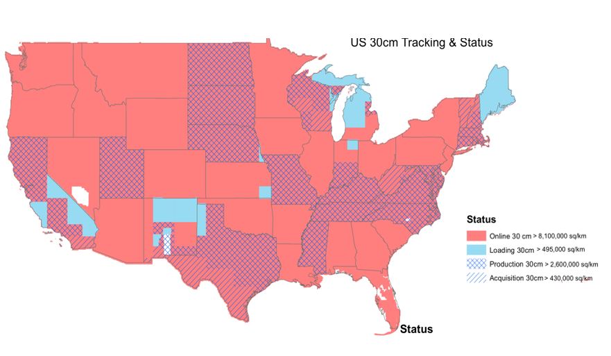
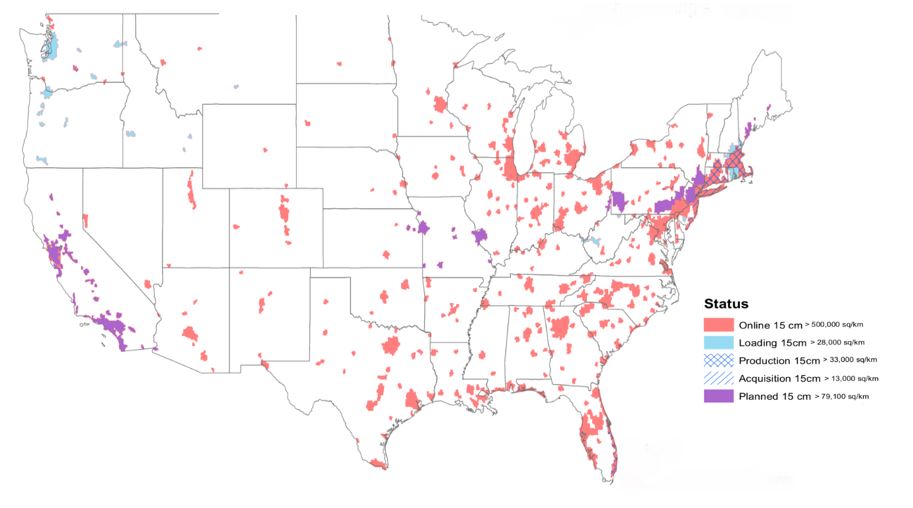
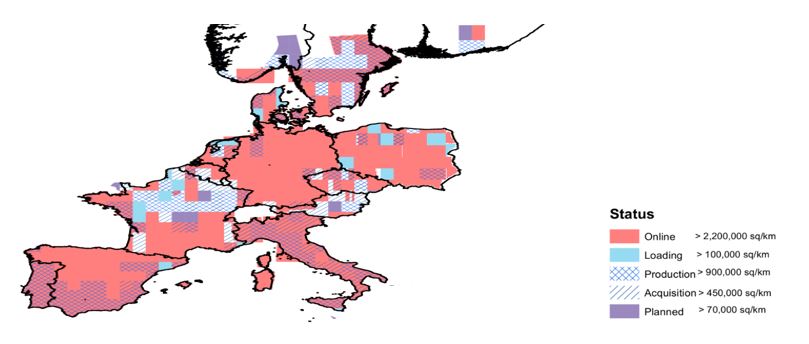
The HxGN Content Program consists of a 30 centimetre image coverage of all the USA and Europe (see figure 1 and 3). The product is updated each second year. Major city areas of the USA are covered at 15 cm (see figure 2).
For all areas, an elevation model is produced by either photogrammetry or LiDAR.
Mapping projects
In recent years, there have been substantial mapping projects throughout Africa where aerial mapping has been used. The projects can be categorised into different subjects:
1) Control of flooding around lakes, rivers, etc., to avoid loss of crops
2) Infrastructure projects to ensure transport by road and rail
3) Open-land use mapping
4) Use of natural resources and re-establishment of these areas
5) Urban management and to ensure the supply of fresh water, electricity, sewage, etc.
6) Environmental protection.
The development projects often only run for a few years, which means that data acquisition has to be accomplished without delays. In the past years, Hexagon’s Geosystems division has witnessed cases where the mapping process took more than two years and the basic development plan could not start until the data was ready.
An example could be the mapping of Uganda, Africa, where open areas have to be mapped with orthophotos with 40-cm accuracy and cities with 15 cm. The project was managed by flying with digital cameras from 2.5- to 7-kilometre altitude. The product is both an orthophoto and a model of terrain. The acquired data will be used for the country’s development projects, such as the control of city planning for Kampala and flooding around Lake Victoria as well as infrastructure projects. A European and Japanese consortium is responsible for the flights and for the primary production of data, and a local team is responsible for the detailed production of vector mapping. Both local know-how and the significant workforce is crucial for the project.
Lesson learned from mapping Uganda is, that in an area with the fickle climate of central Africa the project must have aircrafts ready for flying in the area and keep them there to use for any possible changes to good flying weather. This can be expensive but are essential to get success for mapping project. When the weather is good for aerial mapping, it’s often longer stable periods where aircraft can use the full window – whats not possible by satellites. Use of high-performance sensors and aircraft with local presence is a key factor to success.
A more specific example is the renewal of the railroad in Mozambique, Africa. The track was established years ago as part of a development project, but now renovation of trails and all bridges are of high necessity. The path goes through cliffy terrain where the old railroad is the only way of transportation. Surveying the area by traditional methods or by satellite is not conducive because it would either take too long or the accuracy of the data would be low. A 300-km project like this that requires efficiency and accuracy can be carried out with the latest technology in less than a year.
In the list, there is also Namibia, a large country (825.000 km2) in southwest Africa with a small population (2.2 million) and with a significant lack of infrastructure. All of the country was flown with aircraft from 7- 8-km altitude, and with three campaigns, the land was covered by images with 30-cm resolution. Foreign companies completed the first phase, and the last flight was carried out by external contractors. In addition, a trained local team was responsible for the map production. A similar project was undertaken in the past by satellite surveying methods. The satellite data had acceptable image quality but could not be used to make the vector map – a high-precision model was needed so roads could be planned and changes of the coastline could be monitored.
Challenges and possibilities
All the above projects describe how a large mapping can be used for different developments and highlight the importance of accurate recent data.
Many projects carried out by international large mapping companies face challenges, such as the size of the project and lack of capacity due to the number of the projects a company undertakes. This situation has been the same in the USA and Europe, and for these areas, there have only been maps for each region or country.
Hexagon has choosen to go from national to continental mapping. This is, of cource, a process that will continue over several years. We are sure, however, we can make the basic mapping more effective and lead local partners to the final GIS product, including maps for physical planning and construction work with high presission.
Hexagon’s technology
Hexagon is the first company covering all USA and Europe with high-quality data and with updates every second year. All of the USA is now covered with 30-cm pixel orthophotos, and all major cities are included in the project with 15-cm images. In Europe, the first version of 30-cm coverage is completed. The update and the data for the cities will follow. An oblique programme is in full progress and will soon cover all major city areas of the USA.
Beside effective production, the focus of the HxGN Content Program a multi-use of data so the end user only pays due to actual needs.
By acquiring data above the USA and Europe, and using Leica Geosystems cameras and LiDAR technology solutions, Hexagon covers the mapping datasets needs for several customers. To produce accurate city maps, Hexagon’s Geosystems division has already combined cameras with LiDAR technology for effective data acquisition. These new tools combined with a new highly automated workflow allow us to produce reliable data.
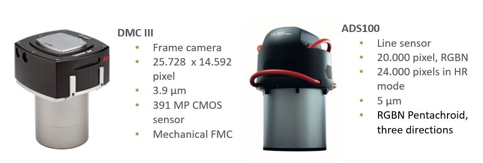
For the image collection, the programme uses the Leica ADS100 image scanner and the Leica DMCIII frame camera.
Hexagon’s sensors give users the possibility to cover 5.5 km in a single flight strip with a speed of 400 km/h for 30-cm orthophotos and the double time for 15-cm. A typical product is aerial images (orthophotos) with a resolution of 10 – 30 cm with an accuracy of 1.5 to 2 pixels. If there is a need for high accuracy on the terrain, Hexagon’s technology enables users to fly with a LiDAR (laser scanning) in the same aircraft and get 10 – 15-cm accuracy on the high. By adding this technology, data can be used for flooding analysing and road and rail design. In line with full workflow for mapping software technology, we will be able to use this new methodology for projects outside the USA and Europe.
What we can do with aircraft is often compared to what we can do with satellites. Both need bright visibility, but as the satellites are flying a minimum of 400 km above ground, Hexagon’s solutions allow users to operate in the range of 2 – 7-km altitude. Satellites pass quickly but are only able to take a few strides per day, so the data is often not as homogeneous as from aircraft and the accuracy can’t be obtained at the same high level. Hexagon will not outdate satellite data, but for areas where data has multiple uses and precision is an issue, the setup Hexagon is using for continental mapping is outstanding.
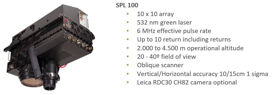
For LiDAR measurements, Hexagon offers both traditional LiDAR with high precision like in the new Leia TerrainMapper and the outstanding Single Photon LiDAR, which has changed what’s possible with laser scanning. The Leica SPL100 system can deliver between 8 and 100+ points/m2 from high altitude and is, therefore, ideal in mountainous areas. With the point density of SPL, it’s not only a system for terrain models but also for detailed mapping with high precision.
To ensure a highly effective workflow for data processing, all data is produced in HxMap, software with a special focus on large-scale mapping projects. The package is handling both LiDAR and image data and is able, in the right data environment, to produce large-scale mapping with the highest degree of automatisation seen so far.
The future
For the new oblique programme for cites in the USA, the Leica CityMapper is used. This instrument is the first commercial instrument to combine data collection of both LiDAR and image data in one sensor. It simply combines the best of the two most common sensor types for mapping and delivering an effective data collection not seen before. In any mapping project, the most expensive part is the aircraft and the crew. Therefore, it makes sense to collect as much data as possible when flying. The CityMapper may not be the first choice for the large-area project in Africa, but the fusion of LiDAR and image collection is for sure a key point in what you will see from Hexagon.
As our world continues to grow in population and development, the need for highly precise maps also grows. Hexagon is committed to providing these maps at the highest quality with the most accurate airborne solutions, supporting those who are shaping smart change around the globe. We are confident the way the HxGN Content Program is organised and the technology behind it can be fully or partly used for major projects in developing countries, both in Africa and for other locations.
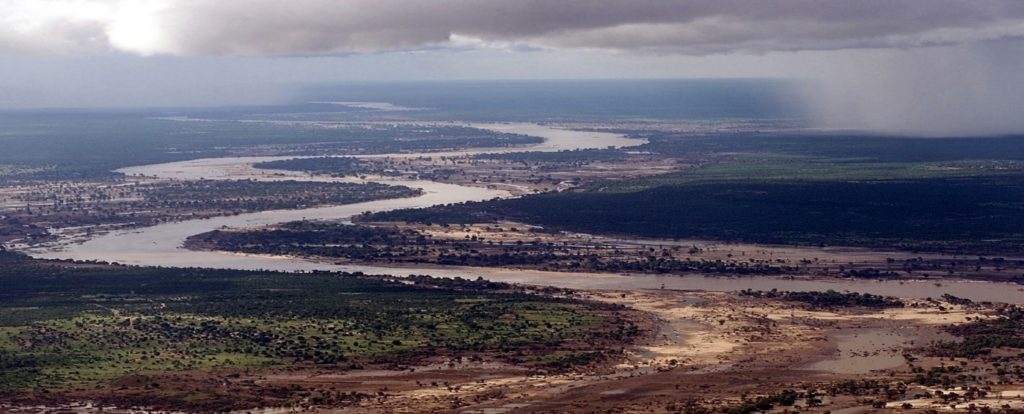
By providing an effective basic mapping, local action can be better and more quickly coordinated. We see it as an essential point to plan updates already at the start of mapping projects. Major cities are changing fast, and an area like Limpopo River is continuously changing. Regular updates of essential areas are a key point for the right and often simple actions to avoiding future disasters.

Chief Product Officer,
Geospatial Content Solutions,
Leica Geosystems