


Construction projects lose a significant profit due to mistakes causing rework, schedule delays and downstream clashes. The current workflow is to spot check key elements with a total station, but this approach is not sufficient – most of the mistakes lurk in the unchecked components!
In this blog, I discuss with Paul Burrows, scanning solutions manager for Europe at Leica Geosystems, how you can optimise your digital construction QA workflows with Verity, powered by JetStream and how you achieve that using reality capture data from various Leica Geosystems sensors.
What is robust quality assurance/quality control (QA/QC ) for construction verification, and why do we need it?
 Paul: Construction mistakes happen. With proper QA and QC verification throughout the early stages of the project, these mistakes can be mitigated using reality capture technology.
There are a couple of key facets to construction verification. We need to visually understand the project’s accuracy and the construction schedule to track the progress over time. To make sure that everything is happening at the right time and the mistakes upstream don’t affect downstream fit-out.
With Verity, powered by JetStream, we can identify those problems as early as possible. We can do that using:
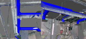
- Clash Detection: Analyse design data against the captured reality
- Flatness & Verticality Analysis: Identify & Report Surface Deviations
What do you mean by reality capture, and what is the workflow users should follow?
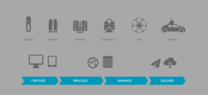 Paul: Users capture data with our terrestrial laser scanners and handheld mobile mapping solutions and process it with Leica Cyclone REGISTER or Cyclone REGISTER 360. Then we have the management aspect. Leica Cyclone ENTERPRISE, a server-hosted solution, allows you to place all your data in one central location. This allows users to load data into various applications, and with Leica TruView LIVE, you will be able to stream point clouds, 3D models and imagery directly into any browser on any platform.
At the “delivery” stage, we have all our Leica CloudWorx products that sit inside a variety of CAD solutions, including Verity, powered by JetStream, an Autodesk Navisworks plug-in that can be paired with CloudWorx for Navisworks to amplify a user’s inspection productivity.
How can users choose the right laser scanning solution for the job?
 Paul: I want to answer the question with a quote by Francois Chardavoine, Head of Production and technology at Lucasfilm and Industrial Light and Magic.
“You want your LiDAR scanning technology to be as portable and easy-to-operate as possible so that you always have the data available. For us, the best scanner is the one you have with you. We’ve been using the BLK360 for a little over one year and a half. Since then, it has become a standard part of arsenal….”
Construction verification depends on the job’s tolerances, on what we are trying to achieve but also, we need to be as accurate as we possibly can in the time frame we have to complete the project. This also depends on which scanning equipment users have access to.
I classify laser scanners in two categories, entry-level in terms of ease of use with the Leica BLK360 and the Leica RTC360, and best-in-class in terms of robustness and accuracy with the Leica ScanStation P30/P40 and ScanStation P50. A third option to use for construction verification would be the Leica BLK2GO handheld mobile mapping solution which is completely valid for these rapid turn-around projects where a large volume of data is required in a short space of time.
We now offer the ability to control the P-Series laser scanners, the RTC360 and the BLK360 using Leica Cyclone FIELD 360. Cyclone FIELD 360 is a tablet and phone-based app for iOS and Android, allowing you to directly interface with the laser scanners to visualise the data and perform a pre-registration directly in the field. It allows you to view project data, check and verify captured information, and add GeoTags such as images, movies, and notes when you are on site. When you transfer that data into Cyclone REGISTER or Cyclone REGISTER 360, you can start your final registration process straight away as all the information you captured in the field is visible in the office.
We have designed a system that allows you to take the data from all these different sensors, combine them in our class-leading registration software, publish the data, and start working with it downstream in solutions such as Verity, powered by JetStream.
What is Verity, powered by JetStream, and how can it help solve the problem of incomplete construction QA?
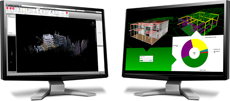
Paul: Verity powered JetStream is a solution developed in partnership with ClearEdge 3D, the makers of Verity. Verity powered by JetStream is a special version of their highly popular product underpinned by JetStream technology for up to 10x analysis speeds versus other formats and works directly in conjunction with CloudWorx for Navisworks. It allows you to compare your design and fabrication models to your as-built point clouds, and it will automatically flag any out-of-tolerance work for rectification. It enables users to check an entire project in a fraction of the time to find construction mistakes before they become costly problems.
How do you get the data ready for Verity, powered by JetStream?
Paul: We have our point cloud data from any of our 3D terrestrial laser scanners or the BLK2GO. We have Navisworks with our design model, which usually comes from somewhere upstream, maybe Revit, and perhaps you have other 3D model data coming directly into Revit too. This is what we want to analyse. You import your reality capture data into Navisworks using CloudWorx and then run the analysis against your Navisworks content using Verity powered by JetStream – it really is very simple!
That will then get you to the reporting stage, where you can create CSV and HTML outputs simply and quickly.
The good thing about Verity powered by JetStream is that you can link back into existing project workflows with Autodesk BIM360, BIM TRACK and Procore for issue tracking. With Verity, you can also use the switchback function of Navisworks if you find something out of tolerance or not at the right place. It allows you to automatically update coordination models in Navisworks to create a true as-built.
Which licences do you need, and which data formats can you use?
Paul: This is a simple process. We have two solutions for pushing data from Cyclone REGISTER 360 and Cyclone REGISTER: Cyclone PUBLISHER or Cyclone PUBLISHER Pro. The main formats we are interested in are the LGS format and data hosted in one of our server products. We use Cyclone PUBLISHER or PUBLISHER Pro to generate data that can be read by CloudWorx for Navisworks.
Leica Geosystems is proud to offer a collection of products developed exclusively for distribution by Leica Geosystems, which leverage our core JetStream technology, bringing universal access to reality capture data via smarter, ‘publish once’ workflows. JetStream powers both a centralised project workflow in our Enterprise management server for collaborative streaming, as well as a local, shareable workflow via LGS files.

Makenna Murray
Senior Product Engineer
Reality Capture Division
For more information on our powered by JetStream solutions, visit our website.
Watch the ‘Optimise your Digital Construction QA Workflows with Verity, powered by JetStream’ webinar.