


History is who we are and why we are the way we are. Without an understanding of our past, meeting the challenges and opportunities of the future becomes more difficult. So preserving the past for future generations couldn’t be more important.
Archaeologists and surveyors face many challenges. However, 3D terrestrial laser scanners such as the Leica ScanStation P-Series product family, are making it easier than ever before to capture and recreate the world our ancestors lived in. Let’s look at a few examples.
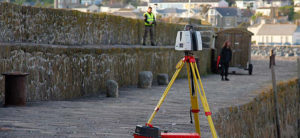
Capturing a British Island
 Running a survey or excavation for months can be costly. So anything that helps archaeologists and surveyors reduce downtime and complete the project faster is welcome. Fortunately, 3D terrestrial laser scanning equipment is transforming the process for creating an accurate digital model of a site.
Nowhere can this more clearly be seen than a project to capture St Michaels Mount in Cornwall, England. This ambitious project aimed to scan and create a high-resolution 3D model of an entire island, including the small village it houses.
In the past, this process would have taken months. However, with a ScanStation P40 and other tools, a fully-textured 3D model was ready in just three days. Scanning at 1 million points per second at ranges of up to 270m, the seemingly huge task of capturing the entire site was transformed into a task of a few days.
Recreating long-lost buildings
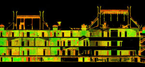 New technology is also helping archaeologists to see interiors, long lost city streets and monuments as they would have looked to previous generations.
3D laser scanning technology allows archaeologists to harness long-range scanning, survey-grade dual-axis compensation and angular accuracy. And these make for highly detailed, hyper-realistic 3D colour point clouds, providing archaeologists with a window into the past.
An example of this in action is the U.S. National Park Service’s (NPS) project to reality capture hurricane-damaged buildings on Ellis Island, NY. The buildings had been closed for decades, but after capturing the site with a ScanStation P40, the NPS was able to see the buildings as they once stood and create an interactive public tour. Developed from panoramic photography, embedded with hyperlinked point cloud animations and 3D meshes captured by the ScanStation, the tour allows the public a glimpse into an otherwise restricted area of one of America’s most iconic sites.
Rebuilding an ancient fort complex in 3D
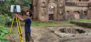 It’s not just working archaeologists who benefit from developments in 3D terrestrial laser scanning. It also has a key role in inspiring the archaeologists of tomorrow.
The ScanStation product family is easy to operate and requires minimal training, making it the perfect teaching resource. Student researchers are able to learn in real-world environments and contribute to the preservation of culturally important sites while they do it.
A perfect illustration of this is a workshop run by Indian National Trust for Art and Cultural Heritage at the fort complex of Rajnagar and the historic gardens of Orchha in India. Using a variety of Leica Geosystems’ equipment (including the ScanStation P40) students learned how to capture and recreate 3D models of the site. This not only contributes to the development of vital skills but also contributes to a live heritage project.
Preserving our heritage
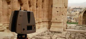 Our cultural heritage is fragile. You only need to consider the recent destruction of Palmyra, or the potential loss of several UNESCO world heritage sites to rising sea levels to see why.
However, archaeologists now have the technology to catch some damage and degradation before it happens. For example, using a ScanStation, a joint research team made up of academics and civil engineers were able to assess earthquake susceptibility in historical monuments along Uzbekistan’s Silk Road.
Thanks to the ScanStation’s ability to scan accurately at ultra-high speeds, the team could quickly collect the data and upload it to Leica Cyclone software and create a fully registered point cloud. This allowed for a thorough analysis of the monuments. At the Registan Square ensemble in Samarkand, the data helped identify the amount of incline in the structure. This allowed local heritage specialists to assess the risk of damage in an earthquake and take steps to reinforce the structure.
3D terrestrial laser scanning even has use in cases where structures can’t be saved. The Temple of Bacchus, part of an ancient Roman City in the Beqaa Valley in Lebanon, has been devastated by war, theft and earthquakes over the years. In fact, it’s been reconstructed several times. But it’s now preserved forever thanks to Leica Geosystems’ 3D terrestrial laser scanning technology.
Using a ScanStation P30, masters students from the Lebanese International University scanned and captured the site in 3D. The point clouds created from this process provided the data need to create an interactive 3D model of the site. So the temple is preserved for future generations to study and enjoy, no matter what the future brings.
Check more information on Leica Geosystems 3D terrestrial laser scanners.
Contact us to learn more about how the Leica ScanStation P-Series is changing the way we capture the past.