


A healthy relationship with the marine world depends on a better understanding of the intricate link between land and water.
Bathymetric maps and hydrographic charts have been used for hundreds of years to help vessels safely navigate the ocean while travelling from port to port, with limited understanding of how human activities might be impacting the ocean environment. As socioeconomic pressure to exploit the riches of the ocean continues to increase, the sea is being used more widely for leisure, fishing and aquaculture, resource extraction, energy generation and other activities that can change the marine ecosystem, which in turn impacts the land. Through frequent mapping, we gain a better understanding of the interaction between water and land. This knowledge supports thoughtful use of the ocean with adequate protection for the existing environment.
The seabed is just submerged land
Traditionally, coastal surveys have been driven by charting authorities for navigation with the primary focus on safety of life at sea. However, with climate change and its effects such as storms, floods, rising sea levels, coastal erosion, underground saltwater intrusion and the destruction of marine life, we are learning that what goes on at sea has a direct impact on what happens on land and vice versa.
Awareness of changes in the physical environment caused by extreme weather events is elevated because more people are living in the coastal environment and there are valuable resources at risk (e.g., homes, fisheries, ports, wind turbines, offshore energy platforms). From the nearshore at sea to far inland, this environment is interconnected.
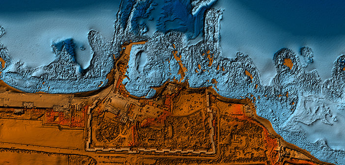
Seamless airborne topographic and bathymetric data of the Israeli Coast. Image courtesy: Hetz
In the past, topographic and bathymetric surveys were conducted using separate sensors and platforms and the data was treated and managed as though it were two discrete worlds. New technology, such as airborne LiDAR, provides the opportunity to observe the land and water as a continuous ecosystem, to be studied together rather than as separate entities. The advantages of this approach are evident as we observe how small changes detected early and modelled can lead to better forecasting and early warning of problems. Good data are necessary to study the impact of human actions throughout the combined ecosystem and make appropriate decisions.
Blue economy offers new opportunities
Countries used to be defined by land mass and assessed by the resources found within their borders; however, when the adjoining sea space is included, the difference can be quite significant. An island with little land mass surrounded by bountiful marine life and offshore resources could change the lives of its residents through sympathetic development. The blue economy offers new opportunities for economic growth and profitability if the ocean’s resources are used in a sustainable way, including preservation and regeneration.
The blue economy already includes offshore renewable energy production, carbon sequestration, seaweed farming and aquaculture, all industries that rely on accurate seafloor mapping data. In addition, the United Nations Convention on the Law of the Sea requires member countries to know where their maritime base lines are located. Regular mapping of the coastal environment is essential to underpin all these activities.
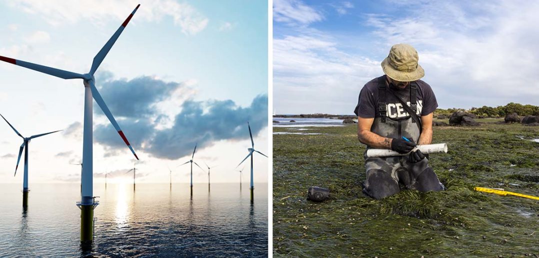
Offshore renewable energy production, carbon sequestration and seaweed farming are part of the blue economy.
Underwater mapping expertise
Bathymetric surveying presents a set of unique challenges due to the dynamic nature of water. Water depths change, sand and seaweed move, the tides reshape the seabed every six or twelve hours and seasonal currents can completely transform the ecosystem. The use of airborne LiDAR provides an opportunity to collect more data, more quickly, over wide areas. Aviation has its own safety concerns, but an aerial survey is considerably faster (flying at 120 knots) than a ship. Instead of a few weeks to make an acoustic survey, a LiDAR survey may be completed in a few days, so the results can provide a better “snapshot” of an area. Regular resurvey improves the ability of researchers to identify and interpret trends and use that information to a much higher level of granularity.
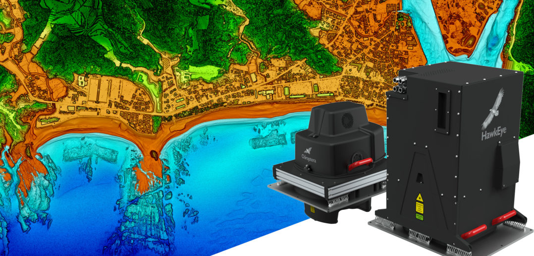
Leica Geosystems offers advanced combined airborne topographic and bathymetric LiDAR solutions.
Hexagon manufactures extremely advanced topographic/bathymetric combined sensors for seamless water, coastal and inland surveying. The Leica Chiroptera 4X and the Leica HawkEye 4X deliver unrivalled point density and depth penetration. Due to the complexity of bathymetric surveying, Hexagon provides a mentoring and knowledge transfer program to facilitate surveys being done at more regular intervals. The company is also considering adding a full-service offering, particularly in regions where the existing model of cost-intensive one-off surveys does not adequately address local needs, funds, and resources.
Collecting data when and where needed
Conditions in coastal areas are changing rapidly on a global scale, creating an urgent need for access to up-to-date bathymetric data. We need to transform the way data are provided; instead of completing large projects only once every ten years or longer, the industry must apply more dynamic models and capture data frequently, especially in nearshore areas where humans interact with the ocean.
The existing HxGN Content Program for aerial imagery allows customers to subscribe and access the coverage they need when they need it. This could be accomplished with bathymetric maps as well, rather than data availability being tied to national budget and collection cycles. The HxGN Content Program in the US is a model for how communities drive data collection, with frequent updates in vulnerable areas. Hexagon engages with our customers to clarify the requirements and ensure delivery, instead of making assumptions about what is needed.
As an industry, we have a responsibility to collaborate and provide the necessary data to the organizations that will help fight climate change and sustainably develop the oceans. Creative business models such as Content Programs will increase the availability of data at a reduced cost to everyone and enable the development of sustainable and profitable solutions for both the land and the sea.
This article was written by Andy Waddington, Hexagon’s VP of Bathymetric Services. Feel free to reach out to Andy for more information on Hexagon’s the blue economy initiatives and bathymetric LiDAR services.
Andy is a hydrographer and an experienced mariner with theoretical knowledge and practical experience from a long career in surveying at sea. He started his career in hydrography in the Royal Navy, UK, where he was originally trained in single beam echo sounders, electronic positioning and horizontal sextant angling in the days before GNSS.
During his 25 years in the Royal Navy he was active in the transition to MBES, the universal adoption of GNSS as the primary positioning system and the introduction of ROVs as a major survey tool. He was also fortunate enough to command a minehunter and an ocean-going survey ship. For the past 10 years he has turned his attention towards other emerging survey techniques and has been involved in the development and operation of bathymetric LiDAR, satellite derived bathymetry and unmanned surface vessels.
Andy has a BSc in Systems and Management and an MSc in GIS and is a Chartered Marine Scientist, a Fellow of the IMarEst, a Member of the Chartered Institute of Civil Engineering Surveyors and an Associate Fellow of the Marine Institute.
Andy leads the business development efforts for Hexagon’s airborne bathymetric systems group, assisting private and government sector users in the successful implementation of technology into a variety of mission requirements for coastal and riparian zone programs.