The Costa Concordia grounding off the coast of Italy in 2012 cost more than 1.5 billion Euros in salvation actions.
The Typhoon Hagibis hit on Japan in 2019 brought estimated damages of more than $15 billion.
Coastal erosion in the United States alone results in more than $500 million a year in damage.
These examples and more showcase the importance and value of bathymetric surveys. The recent topic of a Geo Week panel discussion I had the chance to participate in along with industry colleagues, we discussed how 3D bathymetric models and maps are increasingly being used across applications to protect communities and provide actionable information to those charged with the wellbeing of coastal environments.
Solutions for bathymetric surveying
At Hexagon’s Geosystems division, we offer two airborne sensors specifically for bathymetric surveying:
- Leica Chiroptera 4X
The Leica Chiroptera 4X is a cost-effective and innovative LiDAR system that simultaneously captures 140.000 points per second in the bathymetric channel (full waveform), and up to 500.000 points per second topographic channel, making it the ultimate tool for seamless coastal and land surveying. - Leica HawkEye 4X
The Leica HawkEye 4X offers unrivalled bathymetric point density and water penetration down to 50 m depth at the same accuracy, same turbid water performance, serving the deeper bathymetric LiDAR segment.
With data collection hitting 1 terabyte per day during typical bathymetric surveys, workflow becomes a focal point in processing the vast amount of data. Leica LiDAR Survey Studio is used in conjunction with the airborne sensors to ensure efficient processing. This software provides an extensive software toolbox for processing of multiple missions and simultaneous review of data from all sensor channels. This means that you can review the deep bathymetry, the shallow and the topographic LiDAR data at the same time including reviewing the image taken at the same location as the point cloud data.
Progressing processing power
The future of bathymetric surveying lies in the developments of processing to become more efficient and faster. With this in mind, we have upgraded Leica LiDAR Survey Studio (LSS) 3.0 with advanced algorithms for:
- Increased depth
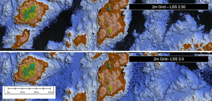
With the new algorithms, the penetration has increased by 10%-20% - Improved accuracy
The deeper a bathymetric survey goes, the less accurate it becomes, due to error sources in the water volume. By modelling and increased utilization of computing power, advanced algorithms are implemented to compensate for this in the LSS 3.0, which improves the accuracy. - Intensified detection of dark objects
Increasing the sensitivity with approximately 50% and decreasing noise in the water column, LSS 3.0 is better able to detect dark objects and delivers higher number of returns on small objects located on sea-bed.

With approximately 1 billion people worldwide living in coastal areas and our ever-growing populating threatening these ecosystems, bathymetric surveying offers an efficient data capturing method for 3D mapping used for sustaining our coastal resources. Creating data sets quicker and more accurately is paramount for the protection of our communities.

With 20 years of experience, working with various airborne technologies, Anders Ekelund serves as Vice President for airborne bathymetric LiDAR of the Hexagon’s Geospatial Content Solutions Division. In this role, he is responsible for developing competitive solutions and services for customers in the bathymetric industry.


