


LOCATORS, LOCATING, DETECTORS, DETECTION, PRECISION AND TRACING
The modern world is full of terminology and words which can mislead or cause confusion. The world of cable locating / detecting can be a minefield of confusing terminology, so why not keep it simple?
A quick look at an online dictionary shows;
So, do we locate or detect cables?
The easiest method for finding a buried pipe or cable is to use a Cable Avoidance Tool. Are we avoiding or locating? Well, a Cable Avoidance Tool is a Cable Locator. The terms are interchangeable.
Is it true that cable locators/detectors do not find pipes or cables? Yes, this is true, and most professionals in the industry know this is factual. The ‘by-product’ of detecting and locating an electromagnetic field associated with flowing A.C. current is the discovery of a pipe and thus cable detection and location. Without an EM field, a cable locator cannot and will not work.
A novice entering the industry can be overloaded with ‘misinformation’ about using the correct terminology – avoiding means locating and locating means detecting. The term tracing adds to the commotion. When I was in grade school, we traced over pictures in books to copy them with grease-proof paper and pencils. Today I trace utility lines, but don’t use greaseproof paper. It’s just a word that has been adapted from the literal meaning.
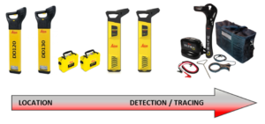
If we discover the position of an electromagnetic field due to a flowing A.C. current in a cable, we are “locating.” If we are extracting information about that signal such as milliamp readings, we are “detecting” and if we follow the line of the cable using both our locate and detect skills then we are “tracing.”
I will close with this thought, when we search for the words detect and locate in a thesaurus, they reference each word as a synonym for the other word. So, an electromagnetic locator encompasses all the following terms; a cable locator, a cable detector and a cable avoidance tool.
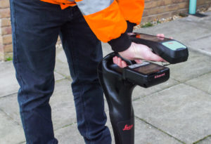
It is a tool comprising of a signal transmitter and a signal receiver. It will have as standard an earth spike, a set of connection leads and as an accessory, a signal clamp. It will come in various levels of complexity with numerous frequencies and applications. As the operator moves from simple locating tasks to more complex detection and tracing tasks, the kit will change its operating use and the appearance of the display screen to become more user-friendly by adjusting orientation in relation to the aerial boards. The operator can easily walk ‘in-line’ with the buried pipe or cable, making tracing tasks much more efficient. These cable locators are classified as precision locators, offering more features and greater accuracy.
As well, sourcing the correct tool is important. Again, I encourage you to keep it simple. Ask the correct questions, use the correct tool for the task, and always use a signal transmitter in conjunction with a signal receiver. These tools are designed to be used as a pair and will offer superior performance when used together.
Better equipment
Since the introduction of the automatic DigiCAT locators in the early 2000s. Leica Geosystems has been a leading innovator in the field of utility detection, simplifying workflows to increase capabilities and efficiently analyse asset performance in less time.
The launch of the new DD SMART utility locator solution allows users to map buried utilities live on-site, transfer data back to base in real-time and remotely access collected information via a hosted service enabling access to multiple sites and their activities for more efficient safety management. The Leica DD Smart locators use cutting-edge technology with industry-leading digital processing technology making underground asset location and identification more intuitive and accurate than ever before.
If your project involves mapping position and depth of buried assets over longer distances, then the Leica Ultra System is your ideal partner. With compass and directional guidance helping the user to confidently locate, detect and map buried assets. Pairing of the Zeno 20 GIS Collector wirelessly to the Ultra System for centimetre RTK positioning and real-time back to base mapping with Leica DX Manager Mapping. The all in one mapping solution for underground assets uploads live via the cloud offering real-time office analysis for fast, precise and efficient digital information sharing.

Steve Davies
Global Trainer – Detection Products, Leica Geosystems part of Hexagon