There are many drawbacks associated with traditional ‘2D’ public safety and mapping workflows. Manually measuring a scene using a tape measure can take significant time to document evidence and can be prone to human error, which can invalidate findings and data. Worse still, vital details of a scene may initially seem insignificant and thus not be captured, leading to critical omissions which only become apparent after the scene has been closed.
There may also be misplaced doubts about the complexity or price of new methods. In reality, 3D public safety workflows will give you the ability to quickly digitise a scene and quickly capture a comprehensive data set that can be revisited anytime in 3D. Evidence collection can be done without disturbing the scene and later used to create compelling 2D and 3D exhibits.
In this blog, we look at 5 of the key benefits of adopting 3D public safety workflows in more detail.
 1. Speed
In any organisation, workers will face pressure from management to complete duties in a timely manner. After all, time is money. But for public safety officials, speed really is of the essence. Take a crime scene investigator, for example. The scene must be documented and recorded quickly and thoroughly before degradation of evidence. Moreover, investigators will need to complete their task quickly to minimise potential disruption to their colleagues, the public or business owners.
The Leica RTC360 3D laser scanner is an automated and highly efficient 3D laser scanner. It can capture a scene in under 2 minutes, regardless of its complexity. To save more time, scan data is automatically visualised on-site with the Leica Cyclone FIELD 360 mobile app; and can be published to Leica TruView Cloud to share the captured scene with project collaborators, no matter where they are located. These integrated platforms enable quick sharing and access of information. Read here to discover why 3D laser scanning is the gold standard.
 2. Simplicity
Akin to speed is simplicity. 3D laser scanning hardware and software should be intuitive to use, reducing the need for extensive training investment and minimising mistakes. The Leica BLK360 is the smallest and easiest-to-use imaging laser scanner in the world. Full-colour panoramic images are overlaid on a point cloud – all at the single click of a button. If you can operate a light switch, you’ll be able to get by with the BLK360. Lightweight and compact, the BLK360 requires minimal setup and break-down and fits in your bag for easy transport.
 3. Accuracy
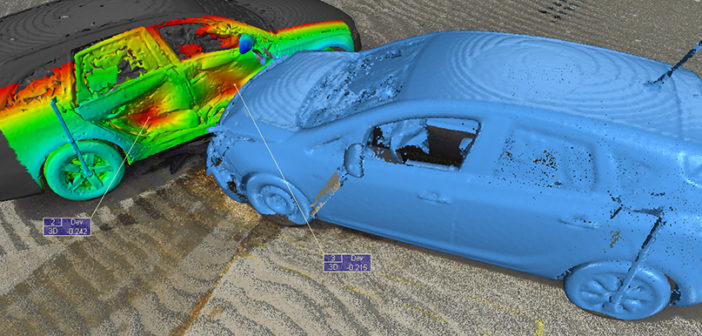
If there’s one thing that no public safety workflow can compromise on, it’s accuracy. On a construction site, accurate scanning could be vital to the structural integrity of a finished build, but at a crash site, accurate data collection is vital to establish cause and liability. At a crime scene, justice often hinges on meticulous evidence collection.
With 3D laser scanners, such as the RTC360, 2 million points can be captured per second to document and visualise the scene. Despite its high speed, there’s no compromise on the quality or accuracy of the captured scan data. Point clouds are clean, without noise or invalid points, which helps when scans are analysed offsite at a later time in the office. Leica Geosystems offers an end-to-end solution for 3D public safety workflows beginning with capture through Cyclone FIELD 360, data processing and preparation in Leica Cyclone REGISTER 360 and finally deliverable creation in Leica Map360 or Leica Cyclone 3DR.
Much like the data collection itself, accuracy in the analysis is essential to public safety workflows. To facilitate this, Leica Map360 makes it easy to create accurate 2D diagrams, incident reconstructions, 3D visuals and other courtroom exhibits. To aid subsequent analysis, evidence can be annotated at the time of scanning in Cyclone FIELD 360. These annotations are preserved throughout the workflow to provide useful context to investigators working in Map360 and shorten the time it takes to create final exhibits.
 4. Safety
3D public safety workflows offer increased safety for both the general public and public safety officials. 3D laser scanners allow public safety personnel to remotely collect evidence out of harms way.
During the scene documentation phase, there may be dangers associated with collecting data. Examples include crash sites on busy roads and fire damaged buildings, or places where the topography is unstable, uneven, or slippery. In such instances, 3D laser scanners are superior to traditional 2D workflows for speed as time spent at dangerous locations is significantly reduced.
 5. Minimising Disruption
Last but not least, 3D public safety workflows are beneficial because they minimise disruption. On account of 3D laser scanning’s superior speed over traditional 2D methods, public safety officials can complete their data collection quickly, allowing any given site to reopen for business-as-usual quicker than before. And because 3D scans are so data-rich, safety officials are not left with doubt that some vital data point has been missed, as could often be the case with a rushed 2D workflow.
The best 3D laser scanners and systems are simple to use, significantly streamlining public safety workflows. What was once a painstaking, time-consuming task can now be completed by fewer specialists more quickly, which has significant cost-saving implications for public safety organisations. With 3D reality capture solutions, public safety officials are safe in the knowledge that not a single shred of data has gone unrecorded.
Leica Geosystems’s comprehensive range of 3D laser scanners and software are easy to use, will speed up your workflow, improve your data accuracy and reduce risk and disruption.
Click here to read our public safety expert insights.
Contact us now to find out more about 3D scanning solutions or contact our experts if you have an enquiry relating to forensic mapping.


