


You can’t hold it in your hand to measure points like a smart antenna. You can’t fly it high in the sky to capture aerial data like a UAV. And you can’t create 3D models with it like point cloud processing software.
If you can’t do any of these things with it, why are HxGN SmartNet GNSS positioning services so important?
HxGN SmartNet makes a variety of amazing, tangible feats possible. Already well known and widely used as a staple for high-accuracy GNSS land survey and construction work, HxGN SmartNet also enables a range of other applications, from helping driverless cars stay in their lane, to precision crop planting and harvesting, to detailed 3D depictions of underground infrastructure.
Spatial data shapes many of today’s solutions, but those solutions are only as strong as the accuracy of the data they are based on.
And this is what makes HxGN SmartNet such a powerful tool across fields and industries, in expected and unexpected places.
With the most extensive network of reference stations around the world, HxGN SmartNet provides the positioning data that is foundational to high accuracy. Through a combination of Network RTK, precise point positioning (PPP) and RTK bridging services, HxGN SmartNet offers global GNSS corrections and, with options to fit a variety of industries and instruments, enables applications that depend on centimetre-level accuracy.
This blog overviews 5 unique cases where the positioning services provided by HxGN SmartNet were crucial to success.
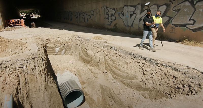
1. Utility mapping for water management
A digital mapping campaign of the water utility infrastructure in Jaén, Spain, used HxGN SmartNet to provide positioning services for measurement data of the water utility infrastructure. Collected with the Leica GS18 I smart antenna, the data was used to create a GIS of the sanitation network, facilitating sustainable water management and updates to ageing infrastructure.
As surveyors captured data with the GS18 I, including piping in trenches in remote areas, they accurately visualised and measured points on their tablets thanks to immediate corrections using HxGN SmartNet Network RTK. This allowed them to complete quality checks on-site and identify and measure individual points. Additionally, HxGN SmartNet ensured point accuracy for all data imported into Leica Infinity, which was used to create digital twins of the infrastructure.
The measurement accuracy of the 3D models enabled by HxGN SmartNet was especially important to help utility managers in Jaén, a drought prone region, create effective water management and infrastructure development plans.
2. Autonomous race car driving
Accurate and real-time centimetre-level positioning is critical for the high-speed autonomous race cars of the worldwide Formula Student Electric driverless challenges, like the Formula Student Germany International Design Competition. First raced in 2010 as part of the larger Formula Student competition, university engineering students design, build, and race self-driving formula style cars, testing the capabilities of their creations across a range of categories.
High-ranked teams from Switzerland and Germany, including ETH Zurich, the Baden-Württemberg Cooperative State University Stuttgart, and more, rely on HxGN SmartNet GNSS corrections and combined GNSS and inertial navigation systems from Hexagon’s NovAtel to track the position of their race cars and measure the boundaries of the track. With this data, they can validate their coordinates and trajectory across the course in real-time for an optimal autonomous performance.
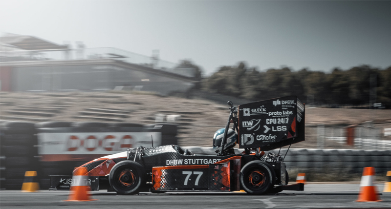
Photo by © DHBW Engineering Stuttgart e.V.
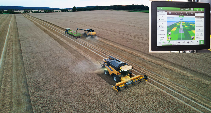
3. Precision farming
Every summer, HxGN SmartNet Product Engineer Stefan Ullrich uses vacation days to help with the harvest on his hometown farm. The farm cooperative in Eastern Germany, in which his father is part owner, integrates precision farming to make seeding, spraying, fertilising, and harvesting more efficient. GNSS corrections are essential to these technologies – without continuous centimetre-level accuracy, you take the precision out of precision farming.
Each year Ullrich connects present with past, experiencing first-hand how SmartNet Network RTK corrections enable futuristic guidance technologies. For example, the crops he harvests are healthy thanks to methods like variable rate spraying that keeps fertilisers and pesticides precisely where they need to be. With an exact record of seeding, individual nozzle-level control, machine guidance, and HxGN SmartNet, farmers can match and spray along the exact crop line, producing less waste, saving fuel, and using fewer pesticides.
During the 2022 harvest, HxGN SmartNet’s positioning accuracy also enabled Ullrich to navigate two synced machines at once. From a combine, he controlled an accompanying trailer, maintaining the optimum distance for uploading the harvested corn.
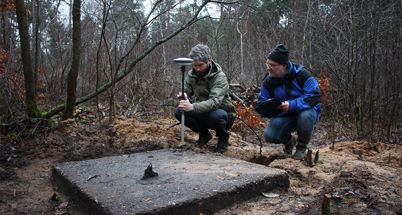
4. Archaeological Survey
As part of an historical discovery study, archaeologists needed to accurately record the geographic location of a 4,000 square metre WWII prisoner of war camp in northern Germany. Collecting data with a Leica GG04 Plus, the team used HxGN SmartNet Network RTK positioning services via a mobile internet connection to achieve the centimetre-level accuracy the project required.
The data was uploaded to Leica Zeno mobile and combined with high resolution aerial imagery from the HxGN Content Program, scanned war time aerial photographs, and contemporary LiDAR imagery. The archaeologists were able to identify excavation sites and stake out points to prepare for new digs.
With the measurements enabled by HxGN SmartNet, the study provided an accurate record to contextualise current work and inform future studies. Additionally, HxGN SmartNet supported the creation of a clear stakeout guide for new excavations with minimal environmental disruption, even in dense forested areas.
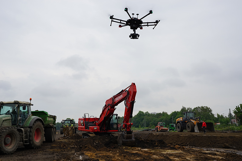
5. UAV surveys for construction
While building a new industrial park near Cologne, Germany, construction company Stricker used HxGN SmartNet to achieve the best positioning quality for their aerial surveys.
Stricker’s construction surveyors collected large amounts of data quickly and safely on the active construction site using UAVs. However, without HxGN SmartNet Network RTK corrections, the data would not have been accurate enough to trust as the basis for the point clouds and digital terrain models created in the surveying office software, Leica Infinity. To make accessing correction data for post-processing even easier, Infinity features a direct HxGN SmartNet integration.
For Stricker’s aerial surveys, HxGN SmartNet corrections were critical to ensure the accuracy of all further processing tasks, like generating volume calculations, site plan profiles, and comparison maps.
While each case uniquely demonstrates how positioning accuracy empowers high precision work, they are only a small sampling of the wide applications possible with the support of HxGN SmartNet positioning services.
To discover additional applications and learn more about how HxGN SmartNet can enable your projects, visit hexagon.com/smartnet.