


This blog post comes from the webinar HxMap – Unified Processing of Airborne Imagery & LiDAR. Watch the webinar here.
When I first started processing airborne sensor data for a survey firm in Finland about a decade ago, the process was time-consuming, siloed and painstakingly tedious. If you were like most survey firms in what I jokingly refer to as the “good ol’ days,” you could have easily been operating multiple types of sensors – large format, medium format and LiDAR – all using their own software programs to process the data.
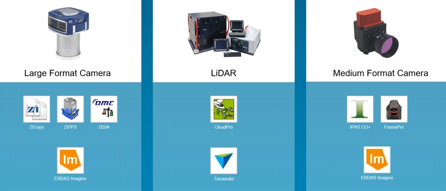
An example of typical large/medium format cameras and LiDAR sensors from about 10 years ago with individual processing workflows.
Human resources were usually trained professionally to process data in one of the workflows. When projects ran smoothly and enough resources were assigned to each silo, the system worked. However, at the first sign of an obstacle, like a cloudy day in one particular project or a massive project that required a lot of processing for one type of sensor data, it was beyond cumbersome to shift and train the resources to support where the work was needed.
When oblique imagery started making its way into the field and the Leica RCD30 Penta Oblique was released, a new workflow was required to process oblique imagery. With the goal in mind to avoid yet another processing silo, the Leica Geosystems team set out to build a processing platform that could process data from any sensor – Leica HxMap was born, one unified high-performance multi-sensor workflow.
Since 2014 when the first version of HxMap was released, the platform has continually been updated to keep up with the technology advancements in airborne sensors. Imagery – both nadir and oblique – as well as LiDAR can now be processed in this one familiar interface through our bundles of airborne sensors and HxMap:
- RealWorld is the combination of the Leica DMC III frame camera sensor with HxMap. This pairing is best suited for large area imaging projects in 2D.
- RealTerrain combines HxMap with either Leica TerrainMapper and Leica ALS80 linear-mode LiDAR sensors or Leica SPL100 single photon LiDAR sensor. This combination is designed for regional and national LiDAR mapping projects.
- RealCity is the combination of the Leica CityMapper or CityMapper-2 hybrid oblique imaging and LiDAR sensor with HxMap. This solution is ideal for 3D city modelling applications and produces 2D imagery products, LiDAR point clouds as well as 3D city models.
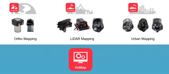
HxMap is the unified high-performance workflow for Leica Geosystems imaging, LiDAR and hybrid sensors.
As HxMap advances, it keeps up with current and future trends in airborne survey.
Upward trend in data volume
As across many parts of our society today, airborne data volume in outstandingly increasing.
In 2010, there was 2 zettabytes of data created worldwide. This year, it is predicted we will reach 59 zettabytes of data created, captured, copied and consumed. -statista.com
While airborne sensors are developed to capture more data from every flight, our customers are not willing to wait longer for our deliverables to be processed. As we collect more and more nadir, oblique and LiDAR content, we need to push this data through much faster than we did even just a few years ago yet at the same or higher quality.
To demonstrate this concept, consider this project where the Leica CityMapper was used to capture nadir and oblique imaging and LiDAR data of Las Vegas, USA. Using a processing cluster of 24 nodes with HxMap, the complete data set was processed in just four days compared to the 62 days it would take to complete the same processing steps on a single workstation.
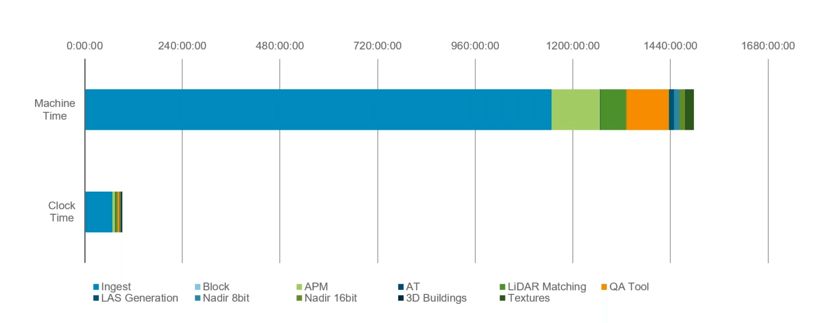
Designed for distributed processing, HxMap processing infrastructure can be easily scaled to significantly reduce processing time.
While HxMap can be run on a single station, most users start with a processing cluster of four to 12 nodes. Depending on the project load and sensors added, the cluster would continuously grow. In extreme cases, customers went as far as moving into a cloud computing state, where they can infinitely extend their processing capacity depending on their project need.
Optimized for distributed processing, HxMap has some key characteristics that considerably simplify the transition into a cloud-based environment:
- Operating system agnostic
HxMap can run on Windows or Linux, making it operational on any suitable cloud-processing environment. - Scriptable processes
Each processing node can run without visual GUI as HxMap has already separated out the tasks, automating the process. - Scalable job manager
HxMap’s job manager, an opensource application known as HTC Condor, is widely used in a variety of sectors such as physics research where not just hundreds but thousands of processing clusters are operating, making it highly operational for any size of project.
How does HxMap further benefit you?
HxMap is a fast, intuitive and efficient post-processing platform, enabling users to produce all known data products within one single common interface. This translates into:
- Simplify training
Working in just one familiar interface across sensors and projects, the downtime for new staff to be trained is significantly reduced. With just one software package, the staff can process either LiDAR or imagery. - Easily create cross-domain expertise
Furthermore to one familiar interface, staff can work across projects. This breaks down silos and easily shifts resources where the work is most needed. - Add flexibility
Depending on the workload – flying time, projects won, new sensors – resources can be deployed across the company to maintain a high level of productivity and quality in one platform. - Invest in single strategy
With the breakdown of silos, you no longer must decide what area receives resources. You can simply invest across the board and rest assured the same workflow will be supported. - Distribute computation resources more freely
Since HxMap is sensor-agnostic, you can freely reuse any processing node for any airborne sensor data. No longer is one workstation or cluster solely dedicated to one project. - Future-proof and expand the processing environmentWhether you’re starting with one sensor or multiple cameras, with one common processing platform, you can add to your processing environment without fear of outdating your systems.
What’s next for HxMap?
The HxMap workflow can generally be divided into two parts.
The first part is built by the individual Sensor Enabler and the HxMap Provider Module. These two components allow the user to load collected data, run ingest to pre-process, apply geo-referencing and then visualise the result to perform quality control. The module additionally includes the workflow manager, our main application that guides the user through the various processing steps. This is where our development team puts their effort into adding support for additional sensors to our HxMap workflow. The latest example is our CityMapper-2 sensor that recently joined the line-up of supported sensors.
The second part of HxMap is where we continue our workflow to create the required products. We divided this into three modules that each add functionality for a given data type or product:
- HxMap Core Imaging Module offers functionality essential to processing imagery datasets. A robust automated point matching generates required tie points between collected imagery across viewing directions. With aerial triangulation will use the measurements to optimise image orientations. HxMap provides multiple triangulation algorithms and a hierarchical process mode for oblique datasets that allows processing of even the largest mapping projects our customers have seen. HxMap triangulation also allows the user to directly apply any misalignment angle to the camera calibration.
- HxMap Core LiDAR Module completes the feature set with all functionality required for LiDAR data processing. A simple one-click LiDAR calibration calculates adjustments to the sensor parameters and outputs an updated project calibration for further processing. Line-to-line registration further improves the matching quality across the full project. At any time, the user can run the built-in QA-tool to evaluate data quality for a single line or the full project.
- HxMap 3D Modeller Module supplements the previous modules. The 3D modelling algorithm takes imagery and LiDAR data either as standalone datasets or together as hybrid data and extracts 3D building geometries. HxMap allows the user to provide known building footprints to generate buildings or directly run building generation without any prior information. Additional information of provided data sets, like point classes or vegetation indices calculated from imagery data, are used to further improve the quality of the extracted buildings.
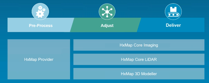
HxMap provider module allows to integrate different sensors and sensor data into the workflow, while HxMap Core Imaging, Core LiDAR and 3D Modeller are constantly developed further to add new features to the software.
It is in this second part of the workflow where we have big plans for the future development of Leica HxMap. Some examples of new features that are currently being worked on and which we plan to release before the end of the year are:
- Ground filtering
By bringing ground classification into HxMap, the workflow is significantly shortened. No longer will you have to take data out of HxMap into a third party software to perform ground filtering and then bring it back in. With our updated algorithms, you can directly perform ground filtering within the same familiar interface. - OrthoMosaic
The addition of creating mosaics from ortho-rectified imagery will allow users to create delivery-ready orthomosaic products all within HxMap. An additional perspective provides functionality like project-wide radiometric normalisation, the option to locally adjust the radiometry, generate and edit seamline as well as combine all together into final ortho tiles. - 3D editor
By adding a 3D Editor to HxMap, users can soon modify the extracted building geometries. Full access to the underlying data allows us to use the imagery for stereo-viewing and display the LiDAR data to further assist the user in applying correctly the adjustment where necessary.
The one-for-all HxMap platform has brought us a long way in the airborne survey sector, and its consistent evolution continues to ensure we avoid the silos of the past. With this overview of the software and look at trends deriving us to the next iteration, the future of our industry is ours for the taking.
To learn more about using HxMap in your next project, watch the webinar with a full project demonstration HxMap – Unified Processing of Airborne Imagery & LiDAR here.

Felix Rohrbach is the product manager for HxMap at Leica Geosystems. With a decade of experience in the airborne mapping industry, he is responsible for the development and adoption of photogrammetry and LiDAR processing software.