


– Selecting the best GIS data collection software for your needs")
In the previous blog, we focused on the steps to build a customised GIS data collection solution and focused on the hardware, including the GNSS sensors and its accuracies, the controller and the setup. This blog explores the Field and Office software you need to build your Fit for Purpose GIS solution.
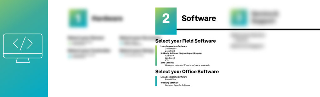
3 Steps to build your Fit for Purpose GNSS solution
The field software
The field software is your interface to manage all aspects of field data collection and enter the required information. As there are many field data capture standards across different application areas, one solution will never meet the requirements of every single customer, so here you can choose among different options:
Zeno Mobile working on Android is a complete data collection app. It has many GIS functionalities whilst being very easy to use and is made specifically for non-surveying specialists. Some of the benefits are:
 Ease of use concept for data collection
- Seamless “over-the-air” data exchange with Esri software
- Connection of various cable locators for mapping underground infrastructure
- Centimetre accuracy no matter with or without Internet connection using HxGN SmartNet cloud service
- Stakeout mode for points and lines with intuitive user guidance
Zeno Field is a professional GIS app running on Windows, which is familiar to Esri users as it is based on the well-known Esri ArcPad.
FieldGenius is an app running on Windows from MicroSurvey, an Hexagon company. FieldGenius is a widely used and popular field software for survey tasks.
3rd party field apps: The above-mentioned apps from Leica Geosystems will meet most of your requirements; however, for extended applications, our sensors can be paired with 3rd party applications. For this, Leica Geosystems uses 3rd party field app on Windows, Android or iOS. This is thanks to Zeno Connect, a lightweight yet powerful to configure GNSS antennas and RTK settings.
Example:
A team of three field workers, each of them with a smartphone or tablet, can share one Zeno Mobile license and one GG04 plus smart antenna. All users can install the app on their individual device, and with the floating Zeno Mobile license users are able to share their solution when required.
The office software
Zeno Office is a Leica Geosystems standard office solution and provides a set of tools for managing and processing GNSS survey data. You can import, edit and post process within the Esri ArcGIS Desktop environment. Zeno Office provides powerful and intuitive EasyIn / EasyOut synchronisation with Zeno Field.
3rd party office software: packages can connect to Leica Geosystem’s field apps in both directions via many exchange formats.
You are free to decide on the solution you would like to go for, whether using Leica Geosystems’ hardware and software or using your own 3rd party app and controller. This flexibility guarantees that maximum integration is achieved in your workflows and application-specific needs and tasks.
With this, you have now been introduced to the many options of software to tailor your Fit for Purpose solution and optimise capturing data in the field using GNSS. Read this blog to learn the hardware set up needed for your GIS data collection.
Explore GIS software, collectors and smart antennas for every application.

Silvia Nunez, Marketing Communications Manager at Leica Geosystems