


Reality capture technology has improved dramatically since 2018 when the Leica RTC360, the first 3D laser scanner to capture one million points per second and leveraging Visual Inertial System (VIS) technology for automatic in-field pre-registration of multiple scan setups was released. Since then, more powerful hardware and software solutions have been developed to increase further the accuracy and efficiency of capturing and processing data. Over the last decade, more building construction companies have adopted reality capture technology to switch from the traditional strings and tapes approach, showing future trends. Today, more than 20% of building construction companies already use even more advanced autonomous technologies on their construction sites.
Although the strings and tapes approach often causes rework that leads to delays and higher costs, it is still being used by many building construction companies. With buildings becoming more complex and the rising need to be more sustainable, the issues can become exponentially more expensive, hurting the company in the long run. But even when reality capture devices are used, the generated deliverables must be shared with all the necessary stakeholders, which is challenging as data silos restrict the free transfer of data. This highlights that building construction companies can significantly improve performance using reality capture hardware and software solutions and adjusting their workflows.
Challenges of the design phase
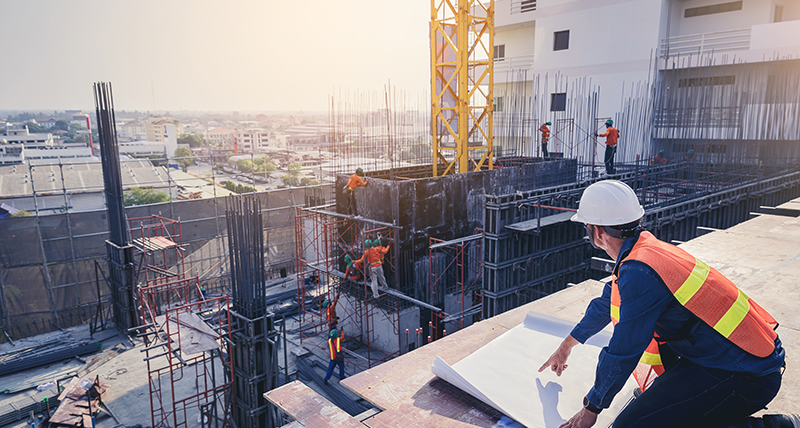
The design phase of a project is essential and is a preliminary indicator if the project will be completed on time and within budget. First, the design model is created with one of the various software solutions available on the market. One important feature is that it can export the design plans in the required format to ensure compatibility with other software and hardware solutions following trades use. Once the design of the construction project is approved, the plans can be made ready for the field team to tackle the project in the physical world.
With a solid strategy, a good and the right tools, the different tasks – from scanning to data processing – are completed efficiently. Manually taking measurements requires multiple team members that drive to the building, and when the measurements are not accurate enough, another trip might be necessary. Repeated trips to the construction site are time-consuming and lead to higher costs and a larger carbon footprint for the company, reducing the number of projects they can work on. Additionally, inaccurate data often cause costly reworks and delays depending on the construction stage and the issues discovered.
Based on the project’s needs, different 3D laser scanners are available to fulfil them and capture buildings, each with its benefits. Terrestrial laser scanners such as the RTC360 have higher performance in terms of accuracy and resolution with their stationary approach while scanning. The Leica BLK360 is the world’s smallest lightweight laser scanner, easy to transport and practical to use in narrow spaces and confined environments. On the other hand, mobile laser scanners such as the Leica BLK2GO can capture the building while walking through it. The mobile approach enables incomparable productivity, making it possible to complete scanning projects where a balance between speed and accuracy is necessary to match client expectations.
This brings us to another issue architects face when using 3D laser scanners for their projects. Their core competence is designing buildings, not reality capture or modelling. This forces every architect to either invest in reality capture hardware and software and have dedicated team members to work on these tasks or use an external service provider. Depending on the circumstances, both options are attractive, but for most, investing in reality capture devices and the fitting software solution will be more profitable in the long term. However, they must create new workflows for their projects to get the most out of this technology to unlock their potential.
Lastly, the data generated from the scans need to be shared with all the involved stakeholders of the project. The existing data formats are not always compatible with some software solutions stakeholders use. A common data environment (CDE) or a cloud-based construction project management tool would both be great platforms to have all parties on the same page and able to work with each other’s data. Implementing this is challenging as the different software solutions would need the option to export the data in a format everyone can use. Although some already use such platforms, it takes time for all construction-related businesses to implement and use them fully and increase efficiency.
Combining products to improve workflows
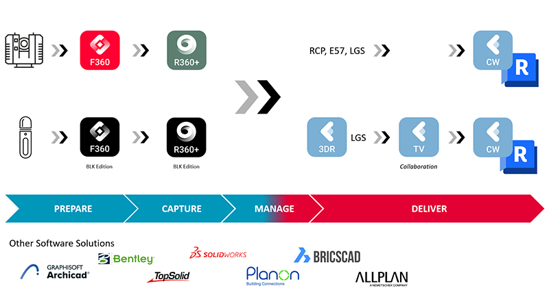
Scanning
From hardware to software solutions, there are many available that can be used for building construction. They can improve accuracy and efficiency independently, but when hardware and software solutions are combined, they can unlock tremendous potential. When investing in new hardware and software solutions, it is essential first to define the needs of every company individually to find the best combination of tools for them.
Depending on a company’s most common type of project, the requirements for a 3D laser scanner differ. Terrestrial and mobile scanners are favourable as they are easy to use while generating accurate point clouds. Autonomous solutions can be programmed to scan buildings with minimal human intervention but are not used as much. Once equipped with a suitable scanner, the building can be captured within a fraction of the time compared to traditional methods. After everything has been scanned, a smooth data transfer with a compatible software solution is the last step before the design team can start to work on the final registration.
Registration
While scanning a building, the generated point cloud data can be viewed, registered and uploaded depending on the hardware and software solutions used. One example is the BLK range of scanners combined with the BLK Live app, which allows you to see the scanning progress live on your mobile device to verify that everything was scanned correctly. During the scanning process, a 2D top view and a 3D rendering of the point cloud are available for progress tracking. A lower point cloud density on the BLK Live app helps to identify an area that needs to be scanned again to increase accuracy.
Another product combination capable of live tracking in the field is Leica Cyclone FIELD 360 paired with the RTC360, which is also compatible with the BLK360. The on-site tagging is a useful functionality, just like the Quick Plan function, which allows you to generate a simple floor plan directly in the field without the need to process it in a separate software solution. If there is a hard-to-reach part of the building where the point cloud is not as accurate, an Apple mobile device with the Cyclone FIELD 360 app can fill the gap using its LiDAR sensors. This highlights the recent developments and how existing and broadly available technology can be combined and used specifically for the project at hand.
The last step before creating deliverables is to register the captured point clouds. Leica Cyclone REGISTER 360 PLUS is a powerful industry-leading software solution that pairs nicely with the RTC360 to deliver an integrated field-to-finished solution. It takes advantage of the RTC360’s Visual Inertial System (VIS) to automatically place and combine the scan data with real-world coordinates. This process can be completed with minimal manual assistance from the user, making it available to a broader audience. Once the entire building is captured, the data is transferred to the office, and the design team can start to process it.
Final deliverables
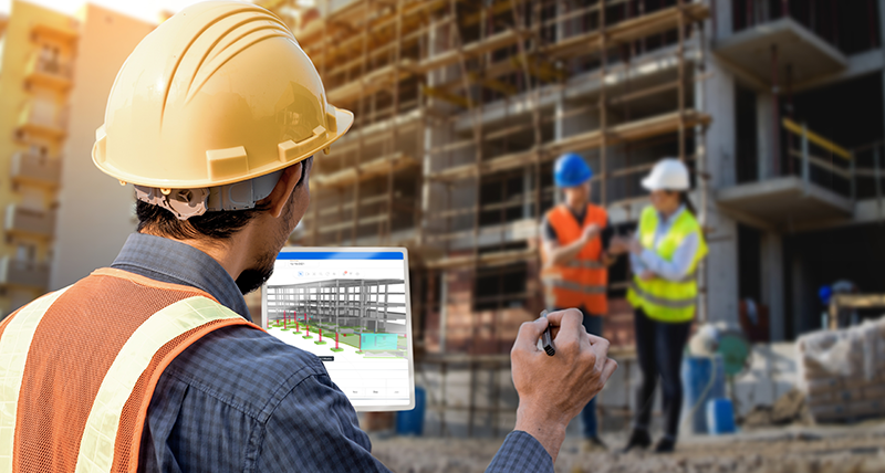
Creating deliverables from the captured data requires a suitable solution and workflow to import, process, visualise, and export in a format all stakeholders can use. Part of the Cyclone family, Leica Cyclone 3DR is the last of the three that works hand in hand with the other Cyclone software solutions. After data collection with Cyclone FIELD 360 and registration in Cyclone REGISTER 360 PLUS, the data can be used to create deliverables with Cyclone 3DR. In contrast to other solutions, Cyclone 3DR does not focus on a single workflow for a specialised deliverable but includes a range of adaptable tools to create and analyse various 3D deliverables. The intuitive and simple workflow of Cyclone 3DR enables construction workers to process the data, create deliverables faster and export it in the correct format.
The final deliverables are then shared with the stakeholders to get everyone on the same page on the project. This allows them to open the deliverable in the software solution of their choice, as many options are available. To do so, it is essential that the final deliverable can be used with different software solutions. Leica CloudWorx, for example, is a great CAD plugin to enable other software solutions to process the point clouds, speed up 2D and 3D deliverable creation and do QA and clash checks. An alternative to the manual processing of the generated data is the cloud-based platform Hexagon Digital Reality (HxDR). With the help of artificial intelligence and machine learning algorithms, it is possible to process the captured data autonomously and create point clouds or mesh files. More tools to autonomously generate deliverables will be added to the HxDR platform to process the data captured with the laser scanners.
The Scan-to-Plan workflow
Equipped with the right hardware and software solutions, the Scan-to-Plan workflow can be initiated and efficiently completed. With a solid Scan-to-Plan workflow a building can be captured with a scanner to then create 3D or 2D deliverables depicting the scanned building as accurately as possible. Based on these deliverables, the client can create precise plans for their project to increase accuracy and efficiency of their office and field teams. In total, eight steps are required to ensure high-quality deliverables are created and shared with the stakeholders.
- Define areas that need to be scanned
- Scan the defined areas of the building
- Register the point cloud
- Export the captured data in the correct format
- Import the data into a compatible software solution
- Process the data and generate 2D or 3D deliverables
- Share with the appropriate stakeholders to make decisions
- Make improvements on or off the construction site
Two examples of a solid workflow are the Vorwerk Wupper Süd and the Villa Boisserée in Germany, where the architect himself scanned the buildings single-handedly within hours using the Leica BLK2FLY and the BLK2GO. A helpful tool was the BLK Live app that allowed him to follow the scanning progress while walking through the buildings to check and verify that every part was scanned.
Another case highlights how a good workflow can massively increase productivity, as the Canadian company DCMS had to scan 15 school and administration buildings with more than 53,000 square metres within eight days. For this task, they used the RTC360 and Leica BLK360 G1 to scan the buildings while simultaneously uploading the generated data by rotating jump drives and batteries to maximise efficiency. This way, their office could start working on the deliverables from the uploaded data while the field team continued to scan the remaining buildings. Depending on the project, this process can be done once or multiple times if verifications are necessary throughout the project.
Scan-to-Plan in the Future
Over the last decade, significant improvements have been made for reality capture, helping construction companies improve the workflow of the design phase. More powerful hardware and software solutions were developed to capture and process the construction site as accurately and efficiently as possible. New technologies and partnerships will improve efficiency and the quality of the deliverables further, especially when hardware and software solutions are compatible and combined for projects.
Capturing construction sites accurately has become easier with existing reality capture technology and will become even easier as new technologies are developed in the future. An example is the Leica BLK2GO PULSE, which uses Time-of-Flight (TOF) camera technology to capture photorealistic images and the dimensions of a room. Additionally, a smartphone can be directly attached and connected for a live view of the point cloud to verify that the defined area has been captured.
Making individual parts of a scanner smaller is a big challenge and will slow the development of revolutionary hardware solutions as these limits are often difficult to overcome. These limits do not apply to software solutions as the automation of processes can be improved, democratising reality capture technology further by enabling end-to-end workflows for everyone. Reality Cloud Studio, powered by HxDR, is one example of a cloud solution that automates the processing of captured data and create registered and meshed digital twins. With this tool, deliverables can be created and used on-site without requiring a team member to register and process the data manually. Decisions can be made on the spot as the data can be easily shared, enabling the stakeholders to adapt their plans according to the available information.
Looking to the future, there will be a shift in the design phase of construction projects. A broader audience will adopt more automated or autonomous solutions to help them improve their workflows. This is especially interesting as younger generations are needed in the construction industry and have a high affinity for technology, and do not necessarily like the physical work. As more projects require reality capture technology, more business opportunities will open up for companies using this technology to ensure profitable operations.
Valentina Albano,
Business Development Manager
Leica Geosystems